IMAGES TAKEN NEAR TO
Plumptre Way, NOTTINGHAM, NG16 3LP
Introduction
This page details the photographs taken nearby to Plumptre Way, NG16 3LP by members of the Geograph project.
The Geograph project started in 2005 with the aim of publishing, organising and preserving representative images for every square kilometre of Great Britain, Ireland and the Isle of Man.

There are currently over 7.5m images from over14,400 individuals and you can help contribute to the project by visiting https://www.geograph.org.uk
Image Map
Images are licensed for reuse under creativecommons.org/licenses/by-sa/2.0
Notes
- Clicking on the map will re-center to the selected point.
- The higher the marker number, the further away the image location is from the centre of the postcode.
Image Listing (21 Images Found)
Images are licensed for reuse under creativecommons.org/licenses/by-sa/2.0
Image
Details
Distance
1
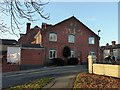
174 Nottingham Road, Eastwood
A commendable modern example of traditional brickwork, the whole side of the house, including the outhouse, being done in Flemish bond. Also incorporated is a polychrome brick rendering of the Phoenix symbol associated with D H Lawrence.
Image: © Alan Murray-Rust
Taken: 12 Nov 2018
0.21 miles
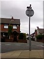
2
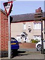
UK Give Way Sign
UK Give Way Sign On Plumptre Way Eastwood, Nottingham Nottinghamshire.
Image: © gary
Taken: 25 Mar 2019
0.22 miles
3
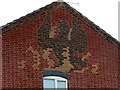
174 Nottingham Road, Eastwood
Detail of the Phoenix in polychrome brick. See http://www.geograph.org.uk/photo/5976067 for location.
Image: © Alan Murray-Rust
Taken: 12 Nov 2018
0.22 miles
4
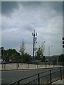
From the Sun Inn, Eastwood, Notts.
The phone mast dominates the view from the Sun Inn to the detriment of the immediate area. Makes the supermarket appear elegant by default.
Image: © Patrick A Griffin
Taken: 9 Jun 2005
0.22 miles
5
UK Back Of A No Entry Sign Pole
UK Back Of A No Entry Sign Pole On Plumptre Way Eastwood, Nottingham Nottinghamshire.
Image: © gary
Taken: 18 Jul 2019
0.22 miles
6
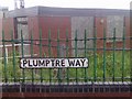
UK Street Road Sign
UK Street Road Sign On Plumptre Way, Eastwood, Nottingham Nottinghamshire.
Image: © gary
Taken: 23 Jul 2019
0.22 miles
7
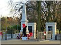
Eastwood War Memorial
The memorial was originally sited on a plot of land near to the Cemetery Chapel off Church Street (approximately 1 km away), but was moved to its present, more prominent, location in 1978. It was further transformed in 2010 with the addition of the wall and panels at the rear, the latter displaying names of victims of the First World War not recorded on the original obelisk. The railings round the obelisk were erected at the same time, replacing chain link fencing. The original elements of the memorial, originally dedicated in 1921, are Listed Grade II.
Image: © Alan Murray-Rust
Taken: 12 Nov 2018
0.23 miles
8
Eastwood Police Station - NG16
A view of the twin pitched-roofs on top of the police station. This "D Division" station is opposite the public library and this is the view along Nottingham Road towards Mansfield Road.
Image: © David Hallam-Jones
Taken: 7 Sep 2012
0.23 miles
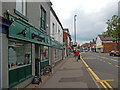
9
South end of Alexandra Street, Eastwood
Just south of the town centre.
Image: © Richard Vince
Taken: 24 Nov 2018
0.23 miles
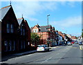
10
Nottingham Road, Eastwood
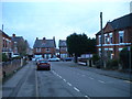
Eastwood has been by-passed for many years but the road here was once part of the A610 between Nottingham and Heanor. The various towns and villages on the route - Nuthall, Kimberley, Giltbrook, Eastwood, Langley Mill and Heanor - long since ran into each other forming a continuous urban corridor. This is Eastwood, a workaday former mining town that has become famous on the back of its D H Lawrence connection. At one time it would have been difficult to find any reference to Lawrence here - his notoriety after the Lady Chatterley obscenity trial of 1960 made him an embarrassment in this socially conservative community - but that has all changed now. Many businesses cash in on the connection including the micropub on the left here which is called 'Gamekeeper's' (a reference to Oliver Mellors, the principal character in 'Lady Chatterley's Lover'). The pub opened in 2017 in a shop that used to sell mobility scooters. On this day it was holding a beer festival in the garden at the back. On the opposite side of the street the sign for the Wellington, a Greene King pub, can just be seen.
Image: © Stephen McKay
Taken: 3 Sep 2022
0.23 miles