IMAGES TAKEN NEAR TO
Newtons Lane, NOTTINGHAM, NG16 2YH
Introduction
This page details the photographs taken nearby to Newtons Lane, NG16 2YH by members of the Geograph project.
The Geograph project started in 2005 with the aim of publishing, organising and preserving representative images for every square kilometre of Great Britain, Ireland and the Isle of Man.

There are currently over 7.5m images from over14,400 individuals and you can help contribute to the project by visiting https://www.geograph.org.uk
Image Map
Images are licensed for reuse under creativecommons.org/licenses/by-sa/2.0
Notes
- Clicking on the map will re-center to the selected point.
- The higher the marker number, the further away the image location is from the centre of the postcode.
Image Listing (47 Images Found)
Images are licensed for reuse under creativecommons.org/licenses/by-sa/2.0
Image
Details
Distance
1
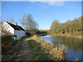
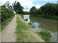
Cottages by the Nottingham Canal
The Nottingham Canal is disused but parts are kept in water https://en.wikipedia.org/wiki/Nottingham_Canal
Image: © Jonathan Thacker
Taken: 10 Feb 2022
0.00 miles
2
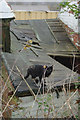
Cat at Bridge Farm
A cat eyes up the photographer from the ramshackle roof of outbuildings at Bridge Farm by the Nottingham Canal.
Image: © Stephen McKay
Taken: 16 Nov 2014
0.01 miles
3
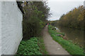
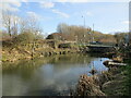
Nottingham Canal, Awsworth
A stretch of the Nottingham Canal with water passes Bridge Farm on the outskirts of Awsworth.
Image: © Stephen McKay
Taken: 16 Nov 2014
0.02 miles
4
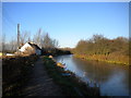
Nottingham Canal west of Awsworth (2)
This section of the long disused canal looks almost as though it would be navigable. A few chickens, presumably from Bridge Farm (left), are foraging on the former towpath.
Image: © Richard Vince
Taken: 13 Dec 2014
0.02 miles
5
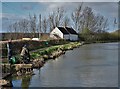
Fishing platforms, north of Newtons Lane
The Awsworth Angling Club have over 50 platforms on this stretch of the former Nottingham Canal [rebuilt after opencast mining]. When mapped in 1880, the building on the left of the towpath was the Robin Hood public house.
Image: © Christine Johnstone
Taken: 21 Jun 2019
0.03 miles
6
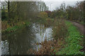
Nottingham Canal, Awsworth
The towpath of the disused canal is a public footpath towards Eastwood.
Image: © Stephen McKay
Taken: 16 Nov 2014
0.04 miles
7
Fishing by The Nottingham Canal
Close to Bridge Farm
Image: © Neil Theasby
Taken: 12 Mar 2020
0.04 miles
8
Nottingham Canal, Awsworth
This stretch of the canal, just south of Bridge Farm, has water but it is very many years since it has been navigable. It used to be known as the 'Top Cut' in this area to distinguish it from the Erewash Canal or 'Bottom Cut'.
Image: © Stephen McKay
Taken: 16 Nov 2014
0.04 miles
9
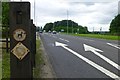
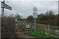
The A6096 east of Cotmanhay
The arrow markings are for a right turn here onto Awsworth Road. The posts protect a pedestrian crossing for people following that route between Cotmanhay and Awsworth
Image: © David Lally
Taken: 24 Jul 2016
0.05 miles
10
Newton's Lane crossing the Nottingham Canal
The bridge has been replaced since the closure of the canal in 1937.
Image: © Jonathan Thacker
Taken: 10 Feb 2022
0.06 miles