IMAGES TAKEN NEAR TO
Ascot Avenue, NOTTINGHAM, NG16 2TU
Introduction
This page details the photographs taken nearby to Ascot Avenue, NG16 2TU by members of the Geograph project.
The Geograph project started in 2005 with the aim of publishing, organising and preserving representative images for every square kilometre of Great Britain, Ireland and the Isle of Man.

There are currently over 7.5m images from over14,400 individuals and you can help contribute to the project by visiting https://www.geograph.org.uk
Image Map
Images are licensed for reuse under creativecommons.org/licenses/by-sa/2.0
Notes
- Clicking on the map will re-center to the selected point.
- The higher the marker number, the further away the image location is from the centre of the postcode.
Image Listing (34 Images Found)
Images are licensed for reuse under creativecommons.org/licenses/by-sa/2.0
Image
Details
Distance
1
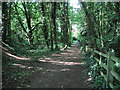
Woodland Footpath, Kimberley
A short footpath (Johnny's Hill) through woodland linking Oak Lodge Drive (Hardy Street) with the playground and park on Eastwood Road.
Image: © Sue Adair
Taken: 27 May 2012
0.07 miles
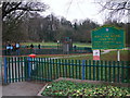
2
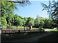
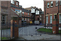
Playground, Kimberley
Playground in Queen Elizabeth II Diamond Fields, Kimberley or locally known as Hall Om Wong, its unusual name from old English summarised as “Mr Hall’s home piece of land”. References date back to the 1700’s.
Image: © Sue Adair
Taken: 27 May 2012
0.10 miles
3
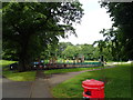
Playground at Hall Om Wong Open Space
The name "Hall Om Wong" is derived from the old English which translates as "Mr Hall's home piece of land". So this is a park in Kimberley covering 7 hectares of land including woodland.
Image: © Eirian Evans
Taken: 9 Jun 2019
0.11 miles
5
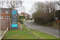
Maws Lane, Kimberley
Maws Lane at its junction with Cornfield Road; Maws Lane Co-op's car park is to the left.
Image: © Stephen McKay
Taken: 11 Mar 2018
0.12 miles
6
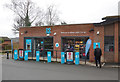
Maws Lane Co-op, Kimberley
This Co-op convenience store opened in September 2016; road access to the car park is via Cornfield Road.
Image: © Stephen McKay
Taken: 11 Mar 2018
0.13 miles
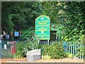
7
Hall Om Wong 'Open Space', Kimberley
Hall om Wong apparently being Old English for "(Mr) Hall's home piece of land". Part of the 'open space' (why not call it a 'park'?) is a Nature Reserve.
Image: © Tim Heaton
Taken: 28 Dec 2008
0.13 miles
9
Hardy and Hanson's Kimberley Brewery
A well respected family firm with a long history, it was bought by independent brewer Greene King in 2006. Sadly, this has resulted in the cessation of brewing on the site, ending a long history of independent brewers in Nottinghamshire. The flag is now basically being flown by micro-breweries.
Image: © Alan Murray-Rust
Taken: 29 Oct 2006
0.14 miles
10
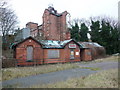
Old Midland Railway Station, Kimberley
With part of the former Hardy and Hanson's brewery behind.
Image: © Tim Heaton
Taken: 28 Dec 2008
0.14 miles