IMAGES TAKEN NEAR TO
Hardy Street, NOTTINGHAM, NG16 2JL
Introduction
This page details the photographs taken nearby to Hardy Street, NG16 2JL by members of the Geograph project.
The Geograph project started in 2005 with the aim of publishing, organising and preserving representative images for every square kilometre of Great Britain, Ireland and the Isle of Man.

There are currently over 7.5m images from over14,400 individuals and you can help contribute to the project by visiting https://www.geograph.org.uk
Image Map
Images are licensed for reuse under creativecommons.org/licenses/by-sa/2.0
Notes
- Clicking on the map will re-center to the selected point.
- The higher the marker number, the further away the image location is from the centre of the postcode.
Image Listing (32 Images Found)
Images are licensed for reuse under creativecommons.org/licenses/by-sa/2.0
Image
Details
Distance
1
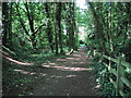
Woodland Footpath, Kimberley
A short footpath (Johnny's Hill) through woodland linking Oak Lodge Drive (Hardy Street) with the playground and park on Eastwood Road.
Image: © Sue Adair
Taken: 27 May 2012
0.10 miles
2
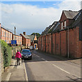
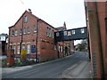
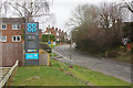
Kimberley: down Hardy Street
Greene King acquired Hardy & Hanson and promptly closed Kimberley Brewery in 2006, with all our woe and loss of Eden.... This is a conservation area and parts of the historic site (on the right) are to be reworked as flats, and the bridge over Hardy Street (ahead) retained.
Image: © John Sutton
Taken: 8 Sep 2017
0.10 miles
3
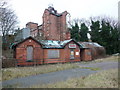
Hardy and Hanson's Kimberley Brewery
A well respected family firm with a long history, it was bought by independent brewer Greene King in 2006. Sadly, this has resulted in the cessation of brewing on the site, ending a long history of independent brewers in Nottinghamshire. The flag is now basically being flown by micro-breweries.
Image: © Alan Murray-Rust
Taken: 29 Oct 2006
0.11 miles
4
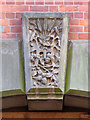
Kimberley keystone
Malting barley, hops and the letter H over a doorway to the former Hardy & Hanson's Kimberley Brewery. At the time this picture was taken the brewery was being converted to flats - see Image
Image: © John Sutton
Taken: 8 Sep 2017
0.12 miles
5
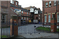
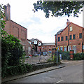
Hardy's and Hanson's Brewery, Hardy Street, Kimberley
Kimberley Ales no more! Bought by Greene King, and then closed. The sign offers 'Land and Buildings with Development Potential'. With this area so rich in Victorian industrial heritage, the planning authorities must hold their ground.
Image: © Tim Heaton
Taken: 28 Dec 2008
0.12 miles
6
Kimberley: Hardy Street and parts of the former Kimberley Brewery
Greene King acquired Hardy & Hanson and promptly closed Kimberley Brewery in 2006, with all our woe and loss of Eden.... This is a conservation area and parts of the historic site are to be reworked as flats, and the bridge retained.
Earlier views of the bridge:
Image] (2005)
Image] (2008)
Image: © John Sutton
Taken: 8 Sep 2017
0.12 miles
7
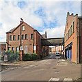
Kimberley Brewery Yard
The brewery closed in 2006. It is in the Kimberley conservation area and is being redeveloped as flats. On a showery September afternoon the sun was briefly behind high clouds. By way of comparison, see Alan Murray-Rust's Image], taken shortly after brewing of one of the finest ales in the country ceased.
Image: © John Sutton
Taken: 8 Sep 2017
0.12 miles
8
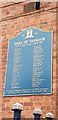
Roll of Honour at former Hardy & Hanson brewery
A Roll of Honour at the former Hardy & Hanson brewery in memory of brewery employees who lost their lives in World War I. It was presented by the company currently redeveloping the site for housing, and unveiled on the 11th of November 2018 by Anna Soubry, the local MP.
Image: © Chris Wood
Taken: 31 Dec 2018
0.13 miles
9
Maws Lane, Kimberley
Maws Lane at its junction with Cornfield Road; Maws Lane Co-op's car park is to the left.
Image: © Stephen McKay
Taken: 11 Mar 2018
0.13 miles
10
Old Midland Railway Station, Kimberley
With part of the former Hardy and Hanson's brewery behind.
Image: © Tim Heaton
Taken: 28 Dec 2008
0.15 miles