IMAGES TAKEN NEAR TO
Little Rickets Lane, NOTTINGHAM, NG15 9HB
Introduction
This page details the photographs taken nearby to Little Rickets Lane, NG15 9HB by members of the Geograph project.
The Geograph project started in 2005 with the aim of publishing, organising and preserving representative images for every square kilometre of Great Britain, Ireland and the Isle of Man.

There are currently over 7.5m images from over14,400 individuals and you can help contribute to the project by visiting https://www.geograph.org.uk
Image Map
Images are licensed for reuse under creativecommons.org/licenses/by-sa/2.0
Notes
- Clicking on the map will re-center to the selected point.
- The higher the marker number, the further away the image location is from the centre of the postcode.
Image Listing (11 Images Found)
Images are licensed for reuse under creativecommons.org/licenses/by-sa/2.0
Image
Details
Distance
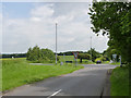
2
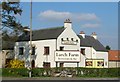
Larch Farm Crossroads, Ravenshead, Notts
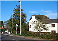
This former farm, now a public house and restaurant with bed & breakfast facilities is shown on ancient maps held at nearby Newstead Abbey to have been here since at least 1825. This is a view from the junction of the A60(the Nottingham to Mansfield road) and the B6020 (Kirkby-in-Ashfield to Blidworth road), with the Kirkby-in-Ashfield section lying behind the photographer. The vehicles are on the A60 are facing in the Nottingham direction. Until 1785 however, it seems that the main highway between Nottingham and Mansfield passed through Papplewick and Newstead Abbey rejoining the present route on the north side of Larch Farm. The former route, known as The King’s Way, passed through Thieves Wood - formerly part of the Royal Wood of Lyndhurst - and it is posited that it was the all too frequent fate of unfortunate travellers that gave the wood its name.
Image: © David Hallam-Jones
Taken: 28 Oct 2014
0.20 miles
4
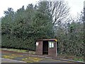
Haggnook Wood
A general view along this sparsely populated cul-de-sac.
Image: © David Hallam-Jones
Taken: 16 Nov 2014
0.21 miles
5
Larch Farm Crossroads, Ravenshead, Notts
This former farm, now a public house and restaurant with bed & breakfast facilities is shown on ancient maps that are held at nearby Newstead Abbey to have been here since at least 1825. This is a view of the B6020 (Kirkby-in-Ashfield to Blidworth road) as it joins the A60 (Nottingham to Mansfield road), with Blidworth lying several miles back behind the photographer. The car ahead is travelling in the Mansfield direction. Until 1785 however, it seems that the main highway between Nottingham and Mansfield passed through Papplewick and Newstead Abbey, rejoining its present route on the other side of Larch Farm, i.e. to the north of it. The former route, known as The King’s Way, passed through Thieves Wood - part of the Royal Wood of Lyndhurst - and it is posited that it was the all too frequent fate of unfortunate travellers that gave this wood its name.
Image: © David Hallam-Jones
Taken: 28 Oct 2014
0.21 miles
6
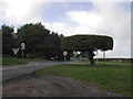
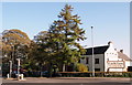
Junction A60 Mansfield Road and Ricket Lane
Someone cares about the tree on the right; it's kept very neat and tidy. The tree, which is a hawthorn, is known as "The Table Top Tree" and it was well established as far back as 1958.
Image: © Tom Courtney
Taken: 25 Sep 2005
0.21 miles
8
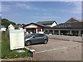
Santini and Sainsbury's
Restaurant and convenience store at the junction of the A60 and B6020.
Image: © David Lally
Taken: 27 May 2018
0.23 miles
9
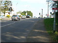
A60 crossroads at Little Ricket Lane
Taken to locate the bench mark seen in these images http://www.geograph.org.uk/photo/4015680 https://www.geograph.org.uk/photo/4015676
Image: © Alan Murray-Rust
Taken: 1 Jun 2014
0.25 miles
10
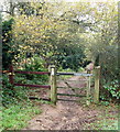
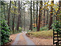
Robin Hood Way, Ravenshead
This section of the path is a 15 minute walk 'in' from the B6020 (the Ravenshead-Kirkby in Ashfield road) towards Newstead Abbey. There are a cluster of residentially lined side roads beyond the fence on the right.
Image: © David Hallam-Jones
Taken: 16 Nov 2014
0.25 miles