1
Papplewick, NG15
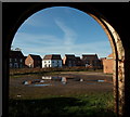
A cluster of new homes on Falcon Way, on the new Papplewick Green residential estate, Papplewick Lane, as seen from inside one of Grange Farm's derelict barns. Grange Farm is situated at the end of Grange Farm Gardens that empties out onto Moor Road (the B683). It is currently "For Sale" with planning permission for the construction of 18 houses.
Image: © David Hallam-Jones
Taken: 17 Nov 2012
0.15 miles
2
Papplewick, NG15 - Grange Farm
Farm buildings on the Grange Farm site. The farm is for sale for 18 residential units with the main access expected to be via the Papplewick Green residential estate on Papplewick Lane, Hucknall (behind the photographer) rather than via Grange Farm Lane, behind this brick building.
Image: © David Hallam-Jones
Taken: 17 Nov 2012
0.16 miles
3
Papplewick, NG15 - Grange Farm
This track connects Grange Farm - currently "For Sale" - and a small number of private homes (Grange Farm Cottages) with Moor Road (the B683) that can be seen in the distance. Behind the photographer and beyond a farm yard area, temporary security fencing has been erected to separate this very dilapidated farm from a housing construction site accessed via Papplewick Lane, Hucknall.
Image: © David Hallam-Jones
Taken: 17 Nov 2012
0.18 miles
4
Papplewick, NG15 - Grange Farm Area
A view of the River Leen travelling in the direction of two long-demolished properties, i.e. Grange Mill and Papplewick Grange. Here the river reappears from beneath a bridge that carries the Grange Farm access track (sometimes referred to as Grange Gardens) from the farm out onto Moor Road (the B683).
Image: © David Hallam-Jones
Taken: 17 Nov 2012
0.19 miles
5
Papplewick Grange, NG15
Although large in size this appears to be the former lodge house at the entrance to the former Papplewick Grange. This private road, albeit a track, is a left hand turning off Moor Road, (the B683) seen here heading towards Papplewick. Behind a boundary hedge to the photographer's right are fields currently in use for arable purposes. This rectangular area, near the boundary with the Griffin's Head pub area and Forest Road (the B6011), is referred to on some maps as Papplewick Moor and it appears that it hosted the Royal Flying Corps Papplewick Moor Station and RAF Papplewick Moor Station between October 1916 - November 1945.
Image: © David Hallam-Jones
Taken: 17 Nov 2012
0.24 miles
6
Papplewick Grange, NG15
These gateposts and gates at the entrance to this private drive leading to the site once occupied by the former Papplewick Grange, off Moor Lane (the B683), appears to be the original ones. The once large mansion was the home of George Robinson, the owner of several cotton mills in Papplewick and following his death, his son James Robinson continued to live there, even after the mills had been sold. The Grange survived the demolition of Grange Mill but was finally pulled down in 1932. Later, "Papplewick Lido", a leisure complex, was built in the grounds. The lido was demolished in 1995 and a cluster of modern houses now occupy part of the site. Beyond the boundary hedge behind the photographer are fields currently being used for arable purposes. This rectangular area, that extends near the boundary of the Griffin's Head pub and Forest Road (the B6011), is referred to on some maps as Papplewick Moor and it appears that it hosted the Royal Flying Corps Papplewick Moor Station and RAF Papplewick Moor Station between October 1916-45.
Image: © David Hallam-Jones
Taken: 17 Nov 2012
0.24 miles


