IMAGES TAKEN NEAR TO
Quarry Lane, NOTTINGHAM, NG15 8GA
Introduction
This page details the photographs taken nearby to Quarry Lane, NG15 8GA by members of the Geograph project.
The Geograph project started in 2005 with the aim of publishing, organising and preserving representative images for every square kilometre of Great Britain, Ireland and the Isle of Man.

There are currently over 7.5m images from over14,400 individuals and you can help contribute to the project by visiting https://www.geograph.org.uk
Image Map
Images are licensed for reuse under creativecommons.org/licenses/by-sa/2.0
Notes
- Clicking on the map will re-center to the selected point.
- The higher the marker number, the further away the image location is from the centre of the postcode.
Image Listing (56 Images Found)
Images are licensed for reuse under creativecommons.org/licenses/by-sa/2.0
Image
Details
Distance
1
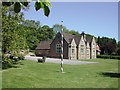
Linby, NG15 - School
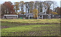
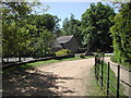
The rear of Linby-cum-Papplewick C.of E.(VA) School as seen from Quarry Lane. The asphalted road peters out behind the photographer and there is a poorly surfaced road (or track ) extending to the former 14 acre Yellowstone Quarry site. Three businessmen formed "Nottingham Bulwell Stone plc." in 2010 and bought the quarry in order to secure the future supply of Bulwell Stone, something that continues to be in demand in conserving many of Nottingham's Victorian buildings. One such Victorian building is the former village school – now a Girl Guides Association centre, the pitched roof of which can be seen beyond the more modern school’s flat roof.
Image: © David Hallam-Jones
Taken: 17 Nov 2012
0.02 miles
2
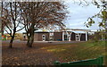
Linby, NG15 - School
Linby-cum-Papplewick Church of England (Voluntary Aided) Primary offers junior level schooling for approximately 120 pupilS from these neighbouring villages. This pedestrian access point is off Quarry Lane. The former Victorian school building - now owned by the Nottinghamshire Girl Guides Association - lies behind the photographer, between him and Main Street, i.e. the B6011 (Linby-Papplewick) road.
Image: © David Hallam-Jones
Taken: 17 Nov 2012
0.02 miles
3
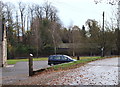
Linby, NG15
The B6011 road that links Linby and Papplewick - visible in the background of this picture - was taken from Quarry Lane at the point where vehicles and pedestrians enter Hanson House. Although these premises were once a Victorian village school it is now owned and used by the Nottinghamshire Girl Guides Association. The replacement village school is located further up Quarry Lane, behind the photographer, as is the former 14 acre Yellowstone Quarry site. Three businessmen formed "Nottingham Bulwell Stone plc" in 2010 and bought the quarry in order to secure the future supply of Bulwell Stone, something that continues to be in demand in conserving many of Nottingham's Victorian buildings.
Image: © David Hallam-Jones
Taken: 17 Nov 2012
0.08 miles
4
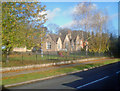
Hanson House
Situated on Main Street and formerly the village school. Now the headquarters for Nottinghamshire Girl Guides.
Image: © Trevor Rickard
Taken: 7 Nov 2009
0.08 miles
5
Former School House, Linby
The school of my father and aunt, many years ago.
Image: © Dave Hitchborne
Taken: 12 Apr 2006
0.08 miles
6
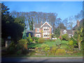
Detached house on Linby Lane
"Inglewood" is one of several large houses on the east side of the village.
Image: © Trevor Rickard
Taken: 7 Nov 2009
0.09 miles
7
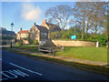
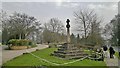
Bottom Cross
The cross was probably erected in 1663. The base and shaft are older, probably Medieval. From its base flows one of the Linby Docks, restored in 1990 (see Image). The cross is thought to mark the western boundary of Sherwood Forest.
Image: © Trevor Rickard
Taken: 7 Nov 2009
0.10 miles
8
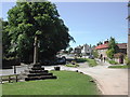
Bottom Cross, Linby
Looking up Main Street towards the Horse and Groom.
Image: © Dave Hitchborne
Taken: 12 Apr 2006
0.11 miles
9
Quarry Lane, Linby
Joins Linby Lane at Bottom Cross.
Image: © Dave Hitchborne
Taken: 12 Apr 2006
0.11 miles
10
Linby Bottom Cross
With water trough at base
Image: © Chris Morgan
Taken: 31 Mar 2014
0.12 miles