IMAGES TAKEN NEAR TO
Mansfield Road, NOTTINGHAM, NG15 8FH
Introduction
This page details the photographs taken nearby to Mansfield Road, NG15 8FH by members of the Geograph project.
The Geograph project started in 2005 with the aim of publishing, organising and preserving representative images for every square kilometre of Great Britain, Ireland and the Isle of Man.

There are currently over 7.5m images from over14,400 individuals and you can help contribute to the project by visiting https://www.geograph.org.uk
Image Map
Images are licensed for reuse under creativecommons.org/licenses/by-sa/2.0
Notes
- Clicking on the map will re-center to the selected point.
- The higher the marker number, the further away the image location is from the centre of the postcode.
Image Listing (21 Images Found)
Images are licensed for reuse under creativecommons.org/licenses/by-sa/2.0
Image
Details
Distance
2

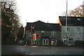
Seven Mile House
Located seven miles from Nottingham on the Mansfield Road. Reputed to have been built by local inhabitants to provide a location to prevent sheep straying from the surrounding farmland towards Nottingham. It is now the head office of a large local firm of housebuilders.
2013 postcript: This http://www.geograph.org.uk/photo/3794238 is a classic example of Geograph's capacity to record change over time.
Image: © Alan Murray-Rust
Taken: 3 Aug 2009
0.07 miles
3
House at Seven Mile Junction
See Image For a while it was the head office of a large local firm of housebuilders (Standen Homes), but it has been To Let now for some time.
Image: © Chris
Taken: 29 Dec 2013
0.08 miles
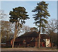
4
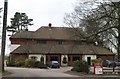
Seven Mile Inn
Roadside pub restaurant on the Mansfield Road, seven miles from Nottingham.
Image: © Alan Murray-Rust
Taken: 3 Aug 2009
0.08 miles
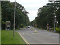
5
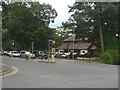
Burntstump Hill, Arnold, NG5, Notts.
The stationary traffic is waiting to pull out into the A60 (the main Nottingham-Mansfield road) at this 'Seven Mile Inn junction'. The other traffic is heading towards one of the turnings - within 2 minutes - leading to one of the following: the Police Headquarters, Sherwood Lodge, The Park Private Hospital Burntstump Country Park or The Burntstump Public House. If individual drivers continue onwards past these they are likely to be using Burntstump Hill as a link to the A614 road (the Nottingham - Doncaster road via Ollerton).
Image: © David Hallam-Jones
Taken: 23 Jan 2015
0.09 miles
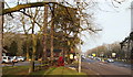
6
Seven Mile Inn, Ravenshead, Notts.
Mature Scots Pine trees in this pub's car park. Mature specimens grow to a height of 35m (115 ft). The A60 road (the main Nottingham-Mansfield road) passes the front of this establishment.
Image: © David Hallam-Jones
Taken: 23 Jan 2015
0.09 miles
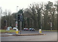
7
Seven Mile junction
The provision of traffic lights at this junction would not appear to be necessary simply from looking at the map, as the road joining the main Mansfield Road at this point is a relatively minor one.
Image: © Alan Murray-Rust
Taken: 3 Aug 2009
0.10 miles
8
Seven Mile Inn, Ravenshead, Notts.
A small pile of snow from a fall on Boxing Day 2014 sitting at the entrance to the car park of Seven Mile Inn. Passing it is the A60 road (the main Nottingham-Mansfield road). The car in the foreground is travelling towards Nottingham whilst a motor-cyclist can be seen turning left into Burntstump Hill, off which can be found Burntstump Country Park. Walkers on the Robin Hood Way (Long Distance Trail) use these traffic lights to cross from Burntstump Country Park to another rural section of it that can be picked up immediately after a road bridge that crosses the former Calverton Colliery Railway track bed 3-4 minutes walk ahead.
Image: © David Hallam-Jones
Taken: 23 Jan 2015
0.12 miles
9
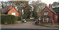
Seven Mile Inn Vicinity, A60, Notts.
These lodges, situated obliquely opposite the Seven Mile Inn (currently a steak house), are situated at the former entrance to a drive leading to Sherwood Lodge. The lodge on the right - a private residence - is dated 1895, whilst the other one - currently in use as a Police Federation (Trade Union) local office - is dated 1903. There is no longer any access into or out of the site onto the road seen here, i.e. the A60 Mansfield to Nottingham road. The original Sherwood Lodge (c. 1790) was the home of the Seely family of politicians, industrialists, landowners and writers. However, the grand house was eventually demolished and replaced by a building - or buildings - that became the former headquarters of the National Coal Board. During the 1970s the premises were used by the Nottinghamshire Police Force. However, more recently a three-storey building costing £18.5 million has been built on the site as the joint headquarters of the Nottinghamshire Police Force and the Nottinghamshire Fire & Rescue Service premises that are accessible from nearby Burntstump Hill.
Image: © David Hallam-Jones
Taken: 23 Jan 2015
0.13 miles