Seven Mile Inn Vicinity, A60, Notts.
Introduction
The photograph on this page of Seven Mile Inn Vicinity, A60, Notts. by David Hallam-Jones as part of the Geograph project.
The Geograph project started in 2005 with the aim of publishing, organising and preserving representative images for every square kilometre of Great Britain, Ireland and the Isle of Man.

There are currently over 7.5m images from over 14,400 individuals and you can help contribute to the project by visiting https://www.geograph.org.uk
Seven Mile Inn Vicinity, A60, Notts.
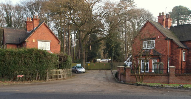
Image: © David Hallam-Jones Taken: 23 Jan 2015
These lodges, situated obliquely opposite the Seven Mile Inn (currently a steak house), are situated at the former entrance to a drive leading to Sherwood Lodge. The lodge on the right - a private residence - is dated 1895, whilst the other one - currently in use as a Police Federation (Trade Union) local office - is dated 1903. There is no longer any access into or out of the site onto the road seen here, i.e. the A60 Mansfield to Nottingham road. The original Sherwood Lodge (c. 1790) was the home of the Seely family of politicians, industrialists, landowners and writers. However, the grand house was eventually demolished and replaced by a building - or buildings - that became the former headquarters of the National Coal Board. During the 1970s the premises were used by the Nottinghamshire Police Force. However, more recently a three-storey building costing £18.5 million has been built on the site as the joint headquarters of the Nottinghamshire Police Force and the Nottinghamshire Fire & Rescue Service premises that are accessible from nearby Burntstump Hill.
Images are licensed for reuse under creativecommons.org/licenses/by-sa/2.0
Image Location
Latitude
53.049075
Longitude
-1.148769