IMAGES TAKEN NEAR TO
Papplewick Lane, NOTTINGHAM, NG15 8EH
Introduction
This page details the photographs taken nearby to Papplewick Lane, NG15 8EH by members of the Geograph project.
The Geograph project started in 2005 with the aim of publishing, organising and preserving representative images for every square kilometre of Great Britain, Ireland and the Isle of Man.

There are currently over 7.5m images from over14,400 individuals and you can help contribute to the project by visiting https://www.geograph.org.uk
Image Map
Images are licensed for reuse under creativecommons.org/licenses/by-sa/2.0
Notes
- Clicking on the map will re-center to the selected point.
- The higher the marker number, the further away the image location is from the centre of the postcode.
Image Listing (23 Images Found)
Images are licensed for reuse under creativecommons.org/licenses/by-sa/2.0
Image
Details
Distance
1
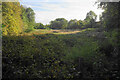
Scrub by Papplewick Lane
This is the valley of the River Leen. It flows over to the right but cannot be seen.
Image: © Bill Boaden
Taken: 15 Oct 2022
0.12 miles
2
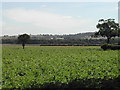
Papplewick Moor from the B683
The mast of the Police HQ at Sherwood Lodge in Burntstump Country Park can just be seen on the hill on the right
Image: © Tom Courtney
Taken: 8 Aug 2005
0.13 miles
3
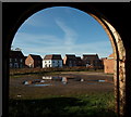
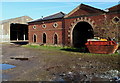
Papplewick, NG15
A cluster of new homes on Falcon Way, on the new Papplewick Green residential estate, Papplewick Lane, as seen from inside one of Grange Farm's derelict barns. Grange Farm is situated at the end of Grange Farm Gardens that empties out onto Moor Road (the B683). It is currently "For Sale" with planning permission for the construction of 18 houses.
Image: © David Hallam-Jones
Taken: 17 Nov 2012
0.14 miles
4
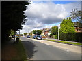
South eastern end of Hayden Lane, Hucknall
Seen from the junction with Papplewick Lane.
Image: © Richard Vince
Taken: 12 Aug 2017
0.14 miles
5
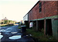
Papplewick, NG15 - Grange Farm
Farm buildings on the Grange Farm site. The farm is for sale for 18 residential units with the main access expected to be via the Papplewick Green residential estate on Papplewick Lane, Hucknall (behind the photographer) rather than via Grange Farm Lane, behind this brick building.
Image: © David Hallam-Jones
Taken: 17 Nov 2012
0.14 miles
6
Papplewick, NG15 - Grange Farm
This track connects Grange Farm - currently "For Sale" - and a small number of private homes (Grange Farm Cottages) with Moor Road (the B683) that can be seen in the distance. Behind the photographer and beyond a farm yard area, temporary security fencing has been erected to separate this very dilapidated farm from a housing construction site accessed via Papplewick Lane, Hucknall.
Image: © David Hallam-Jones
Taken: 17 Nov 2012
0.16 miles
7

An interesting keystone
In the arch of Image Possibly a Green Man representation?
Image: © David Lally
Taken: 27 Oct 2021
0.17 miles
8
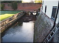
Papplewick, NG15 - Grange Farm Area
A view of the River Leen travelling in the direction of two long-demolished properties, i.e. Grange Mill and Papplewick Grange. Here the river reappears from beneath a bridge that carries the Grange Farm access track (sometimes referred to as Grange Gardens) from the farm out onto Moor Road (the B683).
Image: © David Hallam-Jones
Taken: 17 Nov 2012
0.18 miles
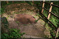
9
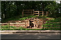
Sluice and shaft at Moor Pond Wood, Papplewick
http://moorpond.papplewick.org/index.html ; http://moorpond.papplewick.org/map_alt.html ;
See: http://moorpond.papplewick.org/documents/audio-script.pdf
The sluice is marked as "Post 12" in the documents above. The sluice is a feature of a mill created by George Robinson, an 18th-19th century businessman. Hailing from Scotland, he eventually settled in the Bulwell area in 1738. He was in the cotton industry around the time when cotton was starting to supersede the linen industry.
Along the valley of the River Leen in the Linby and Papplewick parishes he created several mills and houses for the workers.
Since the mills closed in the 1820s all the embankments in the project area have been planted with oak and ash woodland.
Behind the sluice is Moor Pond. The sluice was discovered (among the trees) and excavated in 2007. It controlled the amount of water going into Moor Pond from the moor (which is the name given to level ground on the other
side of the road).
Behind the stonework is a brick-lined shaft 4m deep (Image). Looking down through the grill (behind the top fence), you can see the slot that contained the sluice. The shaft is an unusual oval shape.
Image: © Chris
Taken: 1 Sep 2012
0.18 miles
10
Sluice and shaft at Moor Pond Wood, Papplewick
See also photo Image
The sluice is a feature of a mill created by George Robinson, an 18th-19th century businessman. Hailing from Scotland, he eventually settled in the Bulwell area in 1738. He was in the cotton industry around the time when cotton was starting to supersede the linen industry.
Along the valley of the River Leen in the Linby and Papplewick parishes he created several mills and houses for the workers.
Since the mills closed in the 1820s all the embankments in the project area have been planted with oak and ash woodland.
Behind the sluice is Moor Pond. The sluice was discovered (among the trees) and excavated in 2007. It controlled the amount of water going into Moor Pond from the moor (which is the name given to level ground on the other side of the road).
Below the grill is a brick-lined shaft 4m deep. Looking down, you can see the slot that contained the sluice. The shaft is an unusual oval shape.
More info.: http://moorpond.papplewick.org/index.html ; http://moorpond.papplewick.org/map_alt.html ;
See: http://moorpond.papplewick.org/documents/audio-script.pdf
Image: © Chris
Taken: 1 Sep 2012
0.18 miles