IMAGES TAKEN NEAR TO
Blatherwick Close, NOTTINGHAM, NG15 7TB
Introduction
This page details the photographs taken nearby to Blatherwick Close, NG15 7TB by members of the Geograph project.
The Geograph project started in 2005 with the aim of publishing, organising and preserving representative images for every square kilometre of Great Britain, Ireland and the Isle of Man.

There are currently over 7.5m images from over14,400 individuals and you can help contribute to the project by visiting https://www.geograph.org.uk
Image Map
Images are licensed for reuse under creativecommons.org/licenses/by-sa/2.0
Notes
- Clicking on the map will re-center to the selected point.
- The higher the marker number, the further away the image location is from the centre of the postcode.
Image Listing (35 Images Found)
Images are licensed for reuse under creativecommons.org/licenses/by-sa/2.0
Image
Details
Distance
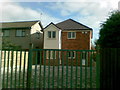
1
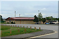
Hucknall Leisure Centre
The nearest building is the latest addition to the complex.
Image: © Alan Murray-Rust
Taken: 7 Jun 2010
0.08 miles
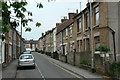
4
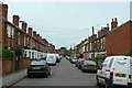
Co-operative Avenue
A typical terraced street in this primarily mining town.
Image: © Alan Murray-Rust
Taken: 7 Jun 2010
0.10 miles
5
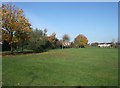
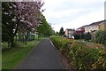
Park near Leen Mills Primary School, Hucknall
Image: © Tim Heaton
Taken: 11 Nov 2012
0.11 miles
7
Albert Street
An early development of terraced houses from the time when the coal industry really got going in Hucknall.
An interesting mixture of stone and brick construction, it appears that the stone is used only for the façade with the remainder of the building being of brick construction. This can be seen on the gable end where the three storey houses start, but was also clear from other observations.
Image: © Alan Murray-Rust
Taken: 7 Jun 2010
0.18 miles
8
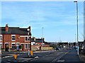
Town Centre Relief Road, Hucknall, Notts.
This 'town centre relief road' is a feature of Hucknall’s current town centre improvement scheme (TCIS). It was opened in November 2016. This is a view from near the town centre end of Annesley Road, looking towards Station Road/Ashgate Road. Buses travelling towards Nottingham from the Wighay area of Hucknall now turn right behind the on-coming white car in order to rejoin High Street. The overall scheme received final funding approval from the Department for Transport in February 2015 (procured using the Medium Scheme Framework 2, through the Midlands Highway Alliance). Carillion/Tarmac JV were awarded the contract and work started on site in January 2016. The work, that includes a pedestrianised section of High Street between Baker Street and Watnall Road, is due to be completed in May 2017. The overall scheme aims to reduce traffic congestion, create an attractive shopping centre, attract new retailers and to assist in the regeneration of the town. Flood prevention measures are being strengthen simultaneously, as part of the project.
Image: © David Hallam-Jones
Taken: 17 Dec 2016
0.19 miles
9
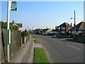
Cycle and foot path beside Bishop's Way
Part of NCN route 6.
Image: © David Lally
Taken: 27 Apr 2017
0.20 miles
10
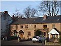
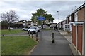
Palmer Road Vicinity, Hucknall, Notts.
A row of former (C19th?) malthouse cottages a stone's throw from the newly created mini-roundabout at the town centre end of Annesley Road. A new 'town centre relief road' (opened in November 2016), that provides motorists with a way of avoiding the soon-to-be-opened pedestrianised section of High Street, passes in front of these houses, separated by a new 6ft tall sandstone wall. Prior to the commencement of the town centre improvement scheme - started in January 2016 and due to be completed in May 2017 - these houses were much less visible to passers-by by virtue of being situated in a secluded mill lane (a cul-de-sac). The property occupiers now have a 14-16 ft tarmacked area between their boundary walls and the relief road's boundary wall. Behind them lies Palmer Avenue and another residential street called The Connery.
Image: © David Hallam-Jones
Taken: 17 Dec 2016
0.20 miles