IMAGES TAKEN NEAR TO
Wigwam Lane, NOTTINGHAM, NG15 7TA
Introduction
This page details the photographs taken nearby to Wigwam Lane, NG15 7TA by members of the Geograph project.
The Geograph project started in 2005 with the aim of publishing, organising and preserving representative images for every square kilometre of Great Britain, Ireland and the Isle of Man.

There are currently over 7.5m images from over14,400 individuals and you can help contribute to the project by visiting https://www.geograph.org.uk
Image Map
Images are licensed for reuse under creativecommons.org/licenses/by-sa/2.0
Notes
- Clicking on the map will re-center to the selected point.
- The higher the marker number, the further away the image location is from the centre of the postcode.
Image Listing (5 Images Found)
Images are licensed for reuse under creativecommons.org/licenses/by-sa/2.0
Image
Details
Distance
1
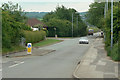
Wigwam Lane
This odd name derives from a Mr. Hankin who after spending some years in America became a Byron tenant. He called his house the Wigwam, and this was the approach. The name dates from the mid 18th century.
Image: © Alan Murray-Rust
Taken: 7 Jun 2010
0.14 miles
2
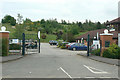
Hucknall Golf Centre
Developed on the spoil tip of the former Hucknall No.2 Colliery.
Image: © Alan Murray-Rust
Taken: 7 Jun 2010
0.14 miles
3

Small canalised stream at Butler's Hill
Passing between industrial units. It joins the river Leen in a few hundred metres.
On the left is the base of a mobile phone mast.
Image: © David Lally
Taken: 27 Apr 2017
0.15 miles
4
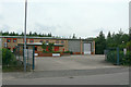
Fairway Court
Industrial units developed as post-coal mining regeneration.
Image: © Alan Murray-Rust
Taken: 7 Jun 2010
0.16 miles
5
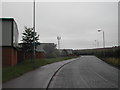
Wigwam Lane, Hucknall
By the industrial site, with the now standard mobile phone mast
Image: © Tom Courtney
Taken: 13 Aug 2005
0.24 miles