IMAGES TAKEN NEAR TO
Shelton Avenue, NOTTINGHAM, NG15 7QA
Introduction
This page details the photographs taken nearby to Shelton Avenue, NG15 7QA by members of the Geograph project.
The Geograph project started in 2005 with the aim of publishing, organising and preserving representative images for every square kilometre of Great Britain, Ireland and the Isle of Man.

There are currently over 7.5m images from over14,400 individuals and you can help contribute to the project by visiting https://www.geograph.org.uk
Image Map
Images are licensed for reuse under creativecommons.org/licenses/by-sa/2.0
Notes
- Clicking on the map will re-center to the selected point.
- The higher the marker number, the further away the image location is from the centre of the postcode.
Image Listing (46 Images Found)
Images are licensed for reuse under creativecommons.org/licenses/by-sa/2.0
Image
Details
Distance
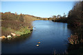
1
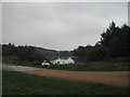
Swans on the Mill Lakes
These lakes at Bestwood Village at one time stored the water for the local water Mill
Image: © Tom Courtney
Taken: 5 Sep 2005
0.07 miles
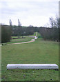
2
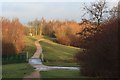
Path Around Mill Lake
The outflow to Mill Lake is under the bridge. This section of the path is on the line of an old railway.
Image: © Mick Garratt
Taken: 5 Jan 2008
0.10 miles
3
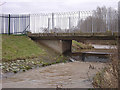
Mill Lakes outlet
This is where the River Leen leaves the Mill Lakes part of Bestwood Country Park
Image: © Alan Murray-Rust
Taken: 13 Jan 2008
0.10 miles
4
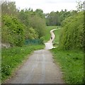
Path into Leen Valley Country Park
This forms part of both the Robin Hood Way and NCN route 6
Image: © David Lally
Taken: 27 Apr 2017
0.12 miles
5
Bestwood Country Park- Mill Lakes area
This is the alignment of the former Great Northern Railway Leen Valley branch. As well as being part of the Robin Hood Way at this point, it is also part of the Sustrans cycle network. The concrete slab in the foreground is a seat, and is inscribed "One million years of pressure", presumably with reference to the formation of the coal seams.
This view is in the opposite direction to Image
Image: © Alan Murray-Rust
Taken: 13 Jan 2008
0.12 miles
6
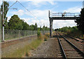
North from Mill Lane crossing
This foot crossing connects Nottingham Road and Bulwell Hall Estate (to the left) and Bestwood. The Robin Hood railway line from Nottingham to Mansfield and Worksop (right) and the NET tramway share the Midland Railway formation (originally double track), which dates from 1848 - the first of three railways built in the Leen Valley and the only one remaining. In the distant past a siding led off to the right from behind the camera to serve the mill shown in Image], and from 1952 the branch line to Calverton Colliery diverged to the right about a quarter of a mile to the north (ahead), just beyond where the Great Northern Leen Valley Line crossed at an angle on a girder bridge of which nothing remains.
Image: © John Sutton
Taken: 13 Jul 2011
0.15 miles
7
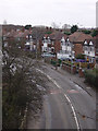
Moor Road, Bestwood Village
The road effectively runs past the end of the former colliery village, and clearly was developed in very different style, being typical semi-detached ribbon development.
Image: © Alan Murray-Rust
Taken: 13 Jan 2008
0.15 miles
8
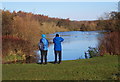
Nottingham, NG6 - Bestwood
One of the "Mill Lakes" in Mill Lakes Country Park from one of the footpaths that encircle it. The water in River Leen that replenishes the lake is seen continuing its journey - at the feet of the birdwatching couple - towards the Moor Bridge tram stop vicinity. This country park is situated between the Nottingham-Mansfield railway line (The Robin Hood Line) on one side and the B683 road on the other, at the point where these two converge to form the apex of an thin inverted triangle at the boundaries of the Ashfield District Council and Nottingham Borough Council administrative areas.
Image: © David Hallam-Jones
Taken: 17 Nov 2012
0.15 miles
9
Mill Lakes
Lake in Bestwood Country Park in the Leen valley
Image: © Richard Croft
Taken: 25 Nov 2011
0.16 miles
10
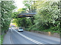
Nottingham - NG6 (Bestwood)
Looking back in the Bestwood Village direction at a stretch of Moor Road (B683) to where a relatively recently installed footbridge carries a nature trail - following a former railway track - across and above the B683.
Image: © David Hallam-Jones
Taken: 16 May 2012
0.17 miles