IMAGES TAKEN NEAR TO
Francklin Road, NOTTINGHAM, NG14 7BG
Introduction
This page details the photographs taken nearby to Francklin Road, NG14 7BG by members of the Geograph project.
The Geograph project started in 2005 with the aim of publishing, organising and preserving representative images for every square kilometre of Great Britain, Ireland and the Isle of Man.

There are currently over 7.5m images from over14,400 individuals and you can help contribute to the project by visiting https://www.geograph.org.uk
Image Map
Images are licensed for reuse under creativecommons.org/licenses/by-sa/2.0
Notes
- Clicking on the map will re-center to the selected point.
- The higher the marker number, the further away the image location is from the centre of the postcode.
Image Listing (56 Images Found)
Images are licensed for reuse under creativecommons.org/licenses/by-sa/2.0
Image
Details
Distance
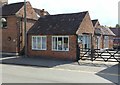
1
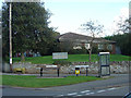
Mens sana in corpore sano
'A healthy mind in a healthy body' - the latin tag is appropriate to a combined Health Centre and Library.
Image: © Alan Murray-Rust
Taken: 17 Oct 2008
0.06 miles
2
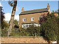
Cockerbeck Cottage
The cottage takes its name from the stream through the village, although it is not particularly close. The large space above the upper storey windows is not uncommon in the district, and presumably was done to give more headroom in the attic.
Image: © Alan Murray-Rust
Taken: 17 Oct 2008
0.06 miles
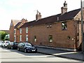
3

Cottages on Main Street
The one at the roadside is a strange one as it is only one room wide, and about 2 or 3 deep. Possibly it was built as a shop, run by the owners of the house behind. Its house number splits the pair of houses behind.
Image: © Alan Murray-Rust
Taken: 17 Oct 2008
0.06 miles
4

The Old School House
The school was moved to a modern building some time ago and the old premises converted to dwellings. Nice to see a working external clock on a private building.
Image: © Alan Murray-Rust
Taken: 17 Oct 2008
0.06 miles
5
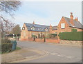
Lowdham, Notts.
With solar panels in place, this is the former primary school in Main Street that was in use until 1988. Part of the building is now a private residence, whilst another part of it houses the village library. The clock was paid for by public subscription and installed to commemorate George V's coronation. The house on the right was the previously the head teacher's house but it is now privately owned. Although this picture gives the impression that these two buildings are joined, they are in fact separated by a path.
Image: © David Hallam-Jones
Taken: 28 Feb 2014
0.08 miles
6
Lowdham, Notts.
The clocked-adorned village library site on Main Street with the local health centre to its rear on Francklin Road. The Francklin family, of nearby Gonalston Hall, were (are?) local landowners. John Henry Browne, who became the vicar in 1842, was instrumental in restoring the then neglected church and raising money and grants to build the village school. This former school building - with the clock - was in use until 1988 when a modern, replacement primary school was built elsewhere in the village. The clock was paid for by public subscription to commemorate George V's coronation.
Image: © David Hallam-Jones
Taken: 28 Feb 2014
0.08 miles
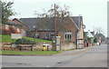
7
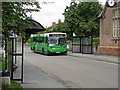
Lowdham
A local bus heads south along Main Street on a journey to Southwell. The building with the clock is the Old School House.
Image: © Stephen McKay
Taken: 2 Aug 2006
0.08 miles
8
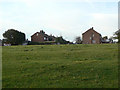
Barker Hill
The housing takes its name from the high ground. This is a council-built estate on the north side of Lowdham.
Image: © Alan Murray-Rust
Taken: 13 Oct 2009
0.09 miles
9
Former framework knitters' workshops, Lowdham
One of a pair of buildings on the corner of Ton Lane and Main Street, now occupied by a soft furnishings firm. Early 19th century, Listed Grade II.
Image: © Alan Murray-Rust
Taken: 13 Jun 2020
0.09 miles
10
Holly Tree Cottage and no.67 Main Street, Lowdham
There is a benchmark http://www.geograph.org.uk/photo/6509416 on no.67 under the nearer white window.
Image: © Alan Murray-Rust
Taken: 13 Jun 2020
0.09 miles