IMAGES TAKEN NEAR TO
Ton Lane, NOTTINGHAM, NG14 7AX
Introduction
This page details the photographs taken nearby to Ton Lane, NG14 7AX by members of the Geograph project.
The Geograph project started in 2005 with the aim of publishing, organising and preserving representative images for every square kilometre of Great Britain, Ireland and the Isle of Man.

There are currently over 7.5m images from over14,400 individuals and you can help contribute to the project by visiting https://www.geograph.org.uk
Image Map
Images are licensed for reuse under creativecommons.org/licenses/by-sa/2.0
Notes
- Clicking on the map will re-center to the selected point.
- The higher the marker number, the further away the image location is from the centre of the postcode.
Image Listing (55 Images Found)
Images are licensed for reuse under creativecommons.org/licenses/by-sa/2.0
Image
Details
Distance
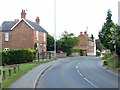
1
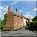
Plough Lane, Lowdham
Part of the older part of the village on the western side of the Cocker Beck. It takes its name from the former Plough Inn, now trading as The World's End.
Image: © Alan Murray-Rust
Taken: 13 Jun 2020
0.05 miles
2
Lowdham, Notts.
A yellow-painted side elevation of "The World's End" pub ahead at the side of Plough Lane. Immediately behind the photographer is Plough Lane's junction with Ton Lane.
Image: © David Hallam-Jones
Taken: 28 Feb 2014
0.05 miles
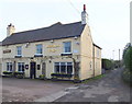
3
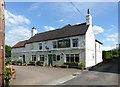
The World's End, Lowdham
Formerly the Plough Inn, the current name derives from a group of cottages at the far end of the lane on the right http://www.geograph.org.uk/photo/6509405 .
Image: © Alan Murray-Rust
Taken: 13 Jun 2020
0.06 miles
4
Lowdham, Notts.
Just ahead, i.e. less than a minute ahead on foot, Plough Lane reaches its junction with Ton Lane. This is the view from a corner of "The World's End" pub, seen here on the right.
Image: © David Hallam-Jones
Taken: 28 Feb 2014
0.06 miles
5
Lowdham, Notts.
Although "The World's End" pub sits on Plough Lane and appears to blend into this semi-rural setting its large car park also spills out - on its other side - onto the A6097 (the Epperstone By-Pass) ensuring that it remains a fairly busy establishment. It dates back to the 1800s and used to be called "The Plough". It was Bill Grice however, the landlord in the 1980s, who decided to change its name to "The World’s End". A blacksmith’s forge once existed opposite the front door of "The Plough". The T-shaped end to this lane ends in two cul-de-sacs. Behind the photographer is its junction with Ton Lane.
Image: © David Hallam-Jones
Taken: 28 Feb 2014
0.07 miles
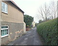
6
Lambley Lane, Lowdham
Part of the older part of the village on the western side of the Cocker Beck.
Image: © Alan Murray-Rust
Taken: 13 Jun 2020
0.07 miles
7
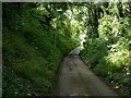
Red Lane, Lowdham
Leading to World's End http://www.geograph.org.uk/photo/6509405 . A classic hollow lane, the name probably derives from the fact that it cuts through the red mudstones which form the local landscape.
Image: © Alan Murray-Rust
Taken: 13 Jun 2020
0.08 miles
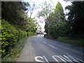
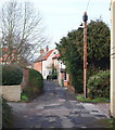
9
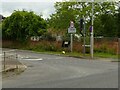
Ton Lane Lowdham
Recreating this 'First' for the square https://www.geograph.org.uk/photo/35716
Image: © Alan Murray-Rust
Taken: 15 Jul 2021
0.10 miles
10
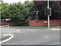
Ton Lane Lowdham
at the junction of the Epperstone By-pass
Image: © Tom Courtney
Taken: 9 Aug 2005
0.11 miles