IMAGES TAKEN NEAR TO
Whinbush Lane, NOTTINGHAM, NG14 6PE
Introduction
This page details the photographs taken nearby to Whinbush Lane, NG14 6PE by members of the Geograph project.
The Geograph project started in 2005 with the aim of publishing, organising and preserving representative images for every square kilometre of Great Britain, Ireland and the Isle of Man.

There are currently over 7.5m images from over14,400 individuals and you can help contribute to the project by visiting https://www.geograph.org.uk
Image Map
Images are licensed for reuse under creativecommons.org/licenses/by-sa/2.0
Notes
- Clicking on the map will re-center to the selected point.
- The higher the marker number, the further away the image location is from the centre of the postcode.
Image Listing (12 Images Found)
Images are licensed for reuse under creativecommons.org/licenses/by-sa/2.0
Image
Details
Distance
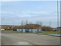
2
Whinbush Lane Vicinity, Calverton, Notts.
Salterford Farm's link with Whinbush Lane.
Image: © David Hallam-Jones
Taken: 4 Jan 2015
0.11 miles
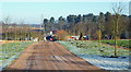
3
Whinbush Lane, Calverton, Notts.
A view of Whinbush Lane looking in the direction of the B6386 (Oxton Road)/ Flatt Lane crossroads.
Image: © David Hallam-Jones
Taken: 4 Jan 2015
0.13 miles
4
Whinbush Lane, Calverton, Notts.
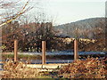
With Salterford Farm stretch of Whinbush Lane running across the middle of this photograph this picture highlights the existence of a pedestrian access point onto a now defunct branch line. This previously served the former Calverton Colliery that closed in 1999. The track bed can be joined here and followed for a mile or so behind the photographer's left shoulder, although for the most part it is heavy on one's footwear and one's ankles too due to the rocky nature of the surface. It is also overgrown in parts. Sansom Wood is a 15 minute walk away
Image: © David Hallam-Jones
Taken: 4 Jan 2015
0.14 miles
5

Salterford Farm, Whinbush Lane Vicinity, Calverton, Notts.
A westward view along the now defunct branch line that previously served the former Calverton Colliery. The colliery closed in 1999. This track can be joined and followed for a mile or so, although for the most part it is heavy on footwear and on one's ankles due to the nature of the surface. Also, it is overgrown in parts. Sansom Wood is a 15 minute walk away ahead of the photographer, where the track can be joined and/or exited.
Image: © David Hallam-Jones
Taken: 4 Jan 2015
0.15 miles
6
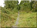
Former railway trackbed
This was the branch line serving Calverton Colliery. There is clearly enough pedestrian use to keep a path clear, although it is a completely unofficial path.
Image: © Alan Murray-Rust
Taken: 27 Sep 2020
0.17 miles
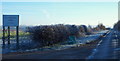
7
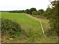
Irrigation pipeline
This stretches at least as far as the railway bridge over the A614.
Image: © Alan Murray-Rust
Taken: 27 Sep 2020
0.18 miles
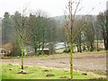
8
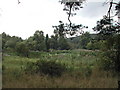
Salterford Dam
In a private wood.........but all I took was the photo
Image: © Tom Courtney
Taken: 12 Aug 2005
0.21 miles
9
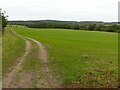
Resown for the winter
Grass field below Watchwood Plantation.
Image: © Alan Murray-Rust
Taken: 27 Sep 2020
0.22 miles