IMAGES TAKEN NEAR TO
Collyer Road, NOTTINGHAM, NG14 6LZ
Introduction
This page details the photographs taken nearby to Collyer Road, NG14 6LZ by members of the Geograph project.
The Geograph project started in 2005 with the aim of publishing, organising and preserving representative images for every square kilometre of Great Britain, Ireland and the Isle of Man.

There are currently over 7.5m images from over14,400 individuals and you can help contribute to the project by visiting https://www.geograph.org.uk
Image Map
Images are licensed for reuse under creativecommons.org/licenses/by-sa/2.0
Notes
- Clicking on the map will re-center to the selected point.
- The higher the marker number, the further away the image location is from the centre of the postcode.
Image Listing (57 Images Found)
Images are licensed for reuse under creativecommons.org/licenses/by-sa/2.0
Image
Details
Distance
1
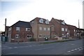
Cherry Tree site, Calverton
The new housing development on the existing Cherry Tree pub site. Nearly ready for the moving in stage.
See Image
Image: © Andrew Barnes
Taken: 24 Feb 2018
0.04 miles
2
Cherry Tree pub, Calverton, Nottingham
The site where this pub stood, land sold to make way for housing development.
See Image
Image: © Andrew Barnes
Taken: Unknown
0.04 miles
3
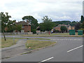
Green at the junction of Collyer Road and Lee Road
Part of the western block of development of Calverton as a colliery village in the 1950s, although the houses actually visible in the picture are not part of the development.
Image: © Alan Murray-Rust
Taken: 14 Aug 2011
0.05 miles
4
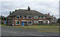
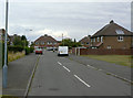
Houses on Collyer Road
Part of the western block of development of Calverton as a colliery village in the 1950s. These examples appear to be more substantial than most, with a double-front appearance. However the side door gives the game away - these are in fact maisonettes, each confined to a single storey.
Image: © Alan Murray-Rust
Taken: 14 Aug 2011
0.14 miles
5
Sherwood Avenue
Part of the western block of development of Calverton as a colliery village in the 1950s and 60s, built by the National Coal Board.
Image: © Alan Murray-Rust
Taken: 14 Aug 2011
0.16 miles
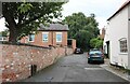
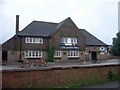
7
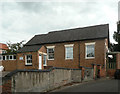
Calverton Village Hall
I have been unable to discover the original use of this building. There is a stone in the right hand gable displaying an open book inscribed 'Bible', so it may well have been a Sunday School.
Image: © Alan Murray-Rust
Taken: 14 Aug 2011
0.16 miles
8
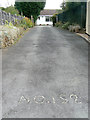
No.152
An unusual way of displaying one's house number.
Image: © Alan Murray-Rust
Taken: 14 Aug 2011
0.16 miles
9
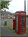
K6 kiosk and Collyer Road, Calverton postbox ref. NG14 105
One of two postboxes with the same name on Collyer Road. Although many K6 kiosks are listed, this one is not.
Image: © Alan Murray-Rust
Taken: 14 Aug 2011
0.17 miles
10
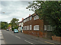
130 Main Street
A small hosiery factory, which would have been equipped with framework knitting machines, a bit of an exception when most of the work was done in private dwellings. Built c1830, with the nearer end possibly slightly later. Listed Grade II. In use as a hosiery factory until 1944, later a printing works, currently a curtains and blinds supplier.
Image: © Alan Murray-Rust
Taken: 14 Aug 2011
0.17 miles