IMAGES TAKEN NEAR TO
Church Meadow, NOTTINGHAM, NG14 6HG
Introduction
This page details the photographs taken nearby to Church Meadow, NG14 6HG by members of the Geograph project.
The Geograph project started in 2005 with the aim of publishing, organising and preserving representative images for every square kilometre of Great Britain, Ireland and the Isle of Man.

There are currently over 7.5m images from over14,400 individuals and you can help contribute to the project by visiting https://www.geograph.org.uk
Image Map
Images are licensed for reuse under creativecommons.org/licenses/by-sa/2.0
Notes
- Clicking on the map will re-center to the selected point.
- The higher the marker number, the further away the image location is from the centre of the postcode.
Image Listing (78 Images Found)
Images are licensed for reuse under creativecommons.org/licenses/by-sa/2.0
Image
Details
Distance
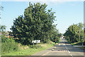
1
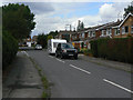
Church Meadow
Modern housing on the south side of Calverton, part of the expansion of the village as a dormitory for Nottingham.
Image: © Alan Murray-Rust
Taken: 14 Aug 2011
0.01 miles
2
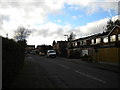
Church Meadow, Calverton
A residential cul de sac off Bonner Hill near to the southern edge of the village.
Image: © Richard Vince
Taken: 25 Oct 2014
0.03 miles
3
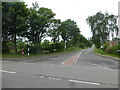
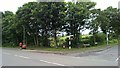
Junction of Bonner Lane with Bonner Hill
Image: © Graham Hogg
Taken: 5 Jun 2018
0.04 miles
4
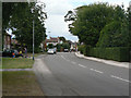
Main Street, Calverton
Looking west from the junction with Bonner Hill.
Image: © Alan Murray-Rust
Taken: 14 Aug 2011
0.04 miles
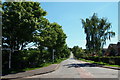
5
Corner of Bonner Hill, and Bonner Lane, Calverton
Interesting position of bus stop, presumably placed in the days of rear entrance buses to keep clear of the junction.
Image: © Chris Morgan
Taken: 5 Jun 2018
0.05 miles
6
Calverton NG14, Notts.
Bonner Hill from the point on this T junction where Main Street becomes Bonner Lane. Further along this road Bonner Hill becomes Foxwood Lane, a road that in turn leads to the village of Woodborough.
Image: © David Hallam-Jones
Taken: 26 May 2013
0.06 miles
7
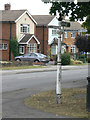
Traditional fingerpost
At the junction of Main Street and Bonner Hill.
Image: © Alan Murray-Rust
Taken: 14 Aug 2011
0.06 miles
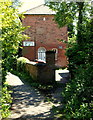
8
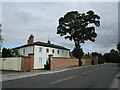
Calverton House
A former vicarage https://historicengland.org.uk/listing/the-list/list-entry/1227469
Image: © Jonathan Thacker
Taken: 17 Sep 2021
0.06 miles
10
Calverton NG14, Notts.
An infant school for forty-four boys and thirty-seven girls was started in the village in 1833. It was supported by the Anglican church and parents contributed a few pence per week. It moved into this purpose-built structure at Burnor Pool in 1846 and became the National School in 1852. It is a brick building with a slated hip roof with access to the first floor being via an external flight of steps. John Roe, a native of Calverton and the founder of a sect known as the Roe-ites performed baptisms were held in a pool in his back garden, Burnor Pool.
Image: © David Hallam-Jones
Taken: 26 May 2013
0.07 miles