IMAGES TAKEN NEAR TO
Pinfold Close, NOTTINGHAM, NG14 6DP
Introduction
This page details the photographs taken nearby to Pinfold Close, NG14 6DP by members of the Geograph project.
The Geograph project started in 2005 with the aim of publishing, organising and preserving representative images for every square kilometre of Great Britain, Ireland and the Isle of Man.

There are currently over 7.5m images from over14,400 individuals and you can help contribute to the project by visiting https://www.geograph.org.uk
Image Map
Images are licensed for reuse under creativecommons.org/licenses/by-sa/2.0
Notes
- Clicking on the map will re-center to the selected point.
- The higher the marker number, the further away the image location is from the centre of the postcode.
Image Listing (90 Images Found)
Images are licensed for reuse under creativecommons.org/licenses/by-sa/2.0
Image
Details
Distance
1
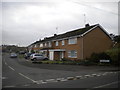
Housing on Pinfold Close, Woodborough
Off Main Street near to the centre of the village.
Image: © Richard Vince
Taken: 25 Oct 2014
0.03 miles
2
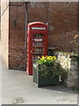
Local exchange
Not of course a telephone exchange! This K6 type telephone kiosk has been converted to a local book exchange where people can come and freely exchange their reading matter. There is a second K6 in the village which is listed, but this one is not.
Image: © Alan Murray-Rust
Taken: 20 Mar 2011
0.04 miles
3
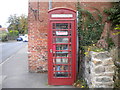
Woodborough Book Exchange
A small, self service library, housed in a former telephone kiosk on Main Street.
Image: © Richard Vince
Taken: 25 Oct 2014
0.04 miles
4
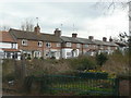
Church Walk
A row of cottages facing onto the stream through the village which runs below the metal fence. The rough ground is the site of the later village Co-operative store, closed just a few years ago.
Image: © Alan Murray-Rust
Taken: 20 Mar 2011
0.05 miles
5
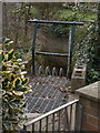
The Sycke Dyke goes underground
One of the tributaries of Main Street Dyke. As with many others, the Main Street Dyke is a natural watercourse which originally ran alongside the village street has been culverted, and is subject to overload. The debris grille and depth marker were installed following the floods of 2007 http://www.geograph.org.uk/photo/483720. Remote monitoring means that build-up can be observed by the authorities and cleared before it becomes a hazard.
Image: © Alan Murray-Rust
Taken: 20 Mar 2011
0.06 miles
6
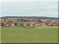
Woodborough village
A view across the fields from the south, showing just how much the village has expanded as a commuter dormitory for Nottingham.
Image: © Alan Murray-Rust
Taken: 20 Mar 2011
0.06 miles
7
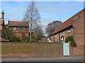
Pigeoncote and barn conversion
The pigeoncote is a typical Nottinghamshire brick-built structure, now converted into a dwelling. Dating from around 1800, Listed Grade II.
Image: © Alan Murray-Rust
Taken: 20 Mar 2011
0.06 miles

9
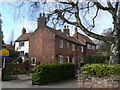
Old Frame Cottage
In practice, this is a pair of cottages with a framework knitter's house at the end of the row, characterised by the large first floor windows to give good light to the workshop. All now converted into a single house. Dating from around 1800, Listed Grade II.
Image: © Alan Murray-Rust
Taken: 20 Mar 2011
0.06 miles
10
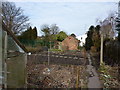
On a public footpath through allotment gardens
Image: © Peter Barr
Taken: 9 Mar 2010
0.08 miles