IMAGES TAKEN NEAR TO
Ploughman Avenue, NOTTINGHAM, NG14 6DE
Introduction
This page details the photographs taken nearby to Ploughman Avenue, NG14 6DE by members of the Geograph project.
The Geograph project started in 2005 with the aim of publishing, organising and preserving representative images for every square kilometre of Great Britain, Ireland and the Isle of Man.

There are currently over 7.5m images from over14,400 individuals and you can help contribute to the project by visiting https://www.geograph.org.uk
Image Map
Images are licensed for reuse under creativecommons.org/licenses/by-sa/2.0
Notes
- Clicking on the map will re-center to the selected point.
- The higher the marker number, the further away the image location is from the centre of the postcode.
Image Listing (39 Images Found)
Images are licensed for reuse under creativecommons.org/licenses/by-sa/2.0
Image
Details
Distance
1
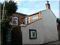
Woodborough Baptist Church
The datestone in the gable carries the date 1831. The chapel was squeezed into a plot of land 'thirteen yards from east to west and 12 yards from south to north'.
Image: © Alan Murray-Rust
Taken: 20 Mar 2011
0.03 miles
2
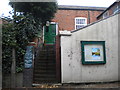
Entrance to Woodborough Baptist Church
On Shelt Hill, which is a very narrow road, hence the limited view of the building.
Image: © Richard Vince
Taken: 25 Oct 2014
0.03 miles
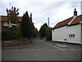
3
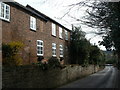
Shelt Hill
The large windows suggest that this might originally have been some sort of a workshop rather than a dwelling which it now is.
Image: © Alan Murray-Rust
Taken: 20 Mar 2011
0.04 miles
4
Thorpe's Cottages
At the bottom of Shelt Hill. This would originally have been a row of seven single-front cottages, but merging has resulted in just three separate dwellings today.
Image: © Alan Murray-Rust
Taken: 20 Mar 2011
0.05 miles
5
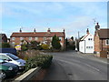
Bottom of Shelt Hill, Woodborough
Its junction with Main Street (left) and Lowdham Lane (which Main Street becomes just out of frame to the right), complete with finger post. I do not envy the bus drivers who have to make the left turn into Shelt Hill from Main Street without colliding with oncoming cars.
Image: © Richard Vince
Taken: 25 Oct 2014
0.06 miles
6
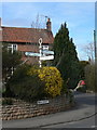
Fingerpost outside Thorpe's Cottages
On the corner of Main Street and Shelt Hill. The cast fingers are more modern replacements for the originals, although the post appears to be original.
Image: © Alan Murray-Rust
Taken: 20 Mar 2011
0.06 miles
7
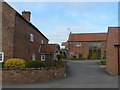
Farm conversion
The small farmhouse (left) and its barns have been converted into modern dwellings.
Image: © Alan Murray-Rust
Taken: 20 Mar 2011
0.06 miles
9
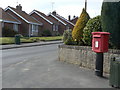
Shelt Hill postbox ref: NG14 218
On the corner of Dover Beck Drive. The latest style of EIIR free-standing small box.
Image: © Alan Murray-Rust
Taken: 20 Mar 2011
0.07 miles
10
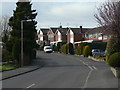
Dover Beck Drive
1970s residential development, part of the expansion of Woodborough as a commuter dormitory for Nottingham.
Image: © Alan Murray-Rust
Taken: 20 Mar 2011
0.07 miles