IMAGES TAKEN NEAR TO
Birch Rise, NOTTINGHAM, NG14 6BT
Introduction
This page details the photographs taken nearby to Birch Rise, NG14 6BT by members of the Geograph project.
The Geograph project started in 2005 with the aim of publishing, organising and preserving representative images for every square kilometre of Great Britain, Ireland and the Isle of Man.

There are currently over 7.5m images from over14,400 individuals and you can help contribute to the project by visiting https://www.geograph.org.uk
Image Map
Images are licensed for reuse under creativecommons.org/licenses/by-sa/2.0
Notes
- Clicking on the map will re-center to the selected point.
- The higher the marker number, the further away the image location is from the centre of the postcode.
Image Listing (24 Images Found)
Images are licensed for reuse under creativecommons.org/licenses/by-sa/2.0
Image
Details
Distance
1
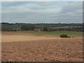
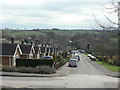
View from Roe Hill
Looking towards Grimesmoor Farm and the hills above Epperstone.
Image: © Alan Murray-Rust
Taken: 20 Mar 2011
0.10 miles
2
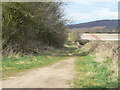
Roe Hill
The extension of the lane beyond the Cemetery, classified as a bridleway and leading to Oxton.
Image: © Alan Murray-Rust
Taken: 20 Mar 2011
0.10 miles
3
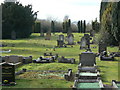
Woodborough Cemetery
On the top of Roe Hill. Burials commenced here in 1879 after the churchyard was declared full. The cemetery is divide by an avenue, and when opened, it was declared Dissenters would be buried in the south side, church people in the north side. This is the Dissenters' side.
Image: © Alan Murray-Rust
Taken: 20 Mar 2011
0.11 miles
4
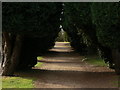
The four-foot gravelled pathway
This was expressly created to divide the site into two, with church people to the north (right) and Dissenters to the south.
Image: © Alan Murray-Rust
Taken: 20 Mar 2011
0.12 miles
5
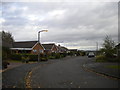
Roe Hill
Looking down towards main Street. The bungalows are a local authority development for older persons, now in the control of a housing trust.
Image: © Alan Murray-Rust
Taken: 20 Mar 2011
0.12 miles
7

Roe Hill
This leads up to the cemetery. The bungalows on both sides are Council-sponsored housing for elderly persons, now in the hands of a housing trust.
The name of the road was originally Roger Lane; the current name refers to an old-established family of market gardeners.
Image: © Alan Murray-Rust
Taken: 20 Mar 2011
0.15 miles
8
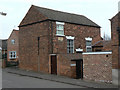
Woodborough Institute
Built in 1827 as a Wesleyan Methodist Chapel.
By the 1880s it was too small for the needs of the congregation and the plot where the current church stands was bought for £20. Thereafter it became an Institute and after various changes of ownership came into the control of the current Trust in 1950, with the following provisions*:
'For the purposes of physical and mental training, recreational and social, moral and intellectual development through the medium of a reading and recreation room. Lectures, classes, games, whist drives, youth club recreations and entertainments. Provision to be particularly made for the entertainment and use of the Institute by the old folk of the Parish of Woodborough, and to be used generally for the benefit of the inhabitants of Woodborough and its immediate vicinity without distinction of sex or of political, religious or other opinions.... The control of the Institute to be entirely non-sectarian. The Institute may be used by any political parties for whist drives or other entertainments with the consent of the (Trustees) but no political speeches of any kind whatsoever shall be made in the Institute at any time'.
It is still in use as a village meeting room.
*Quoted from Woodborough Heritage website www.woodborough-heritage.org.uk
Image: © Alan Murray-Rust
Taken: 20 Mar 2011
0.20 miles
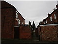
10

New Row
Housing on Roe Hill. Part of a 19th century development which included the framework knitters' cottages typical of the area. The main group has now been replaced with modern housing and only this group survive.
Image: © Alan Murray-Rust
Taken: 20 Mar 2011
0.20 miles