IMAGES TAKEN NEAR TO
Stoke Lane, NOTTINGHAM, NG14 5HR
Introduction
This page details the photographs taken nearby to Stoke Lane, NG14 5HR by members of the Geograph project.
The Geograph project started in 2005 with the aim of publishing, organising and preserving representative images for every square kilometre of Great Britain, Ireland and the Isle of Man.

There are currently over 7.5m images from over14,400 individuals and you can help contribute to the project by visiting https://www.geograph.org.uk
Image Map
Images are licensed for reuse under creativecommons.org/licenses/by-sa/2.0
Notes
- Clicking on the map will re-center to the selected point.
- The higher the marker number, the further away the image location is from the centre of the postcode.
Image Listing (18 Images Found)
Images are licensed for reuse under creativecommons.org/licenses/by-sa/2.0
Image
Details
Distance
1
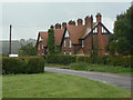
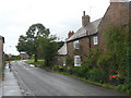
Cottages on Stoke Lane
One of several groups of cottages built at different times on the Stoke Bardolph estate. These date from the end of the 19th century.
Image: © Alan Murray-Rust
Taken: 25 Aug 2009
0.02 miles
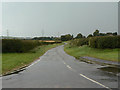
2
Farm road
One of the legacies of the former City Council regime at the Stoke Bardolph sewage farms is the network of hard surfaced tracks for field access.
Image: © Alan Murray-Rust
Taken: 25 Aug 2009
0.06 miles
3
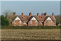
Estate cottages, Stoke Bardolph
Built around 1900 by Nottingham Corporation as part of the development of the Stoke Bardolph sewage farm.
Image: © Alan Murray-Rust
Taken: 31 Dec 2020
0.07 miles
4
Cottages on Stoke Lane
One of several groups of cottages built at different times on the Stoke Bardolph estate. With their brick outhouses, this group look as if they have been transplanted from an inner-city location.
Image: © Alan Murray-Rust
Taken: 25 Aug 2009
0.07 miles
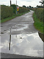
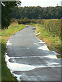
5
Stoke Lane
This is the back way into the village, but may have been the main road originally. It doesn't appear to fulfil any purpose as there are no properties abutting it.
Image: © Alan Murray-Rust
Taken: 25 Aug 2009
0.08 miles
6
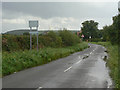
Mystery road sign
What will it reveal when it is hinged open?
Image: © Alan Murray-Rust
Taken: 25 Aug 2009
0.12 miles
7
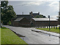
Stoke Bardolph Village Hall?
It's not clear if this is the village hall, as there are no signs, but it is clearly some form of meeting place. The old Manor Farm House lurks in the background.
Image: © Alan Murray-Rust
Taken: 25 Aug 2009
0.13 miles
8
Stoke Lane
This is the back way into the village, but may have been the main road originally. It doesn't appear to fulfil any purpose as there are no properties abutting it.
Image: © Alan Murray-Rust
Taken: 25 Aug 2009
0.15 miles
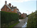
9
Hebb Farm House
One of the houses in the village that predates the establishment of the sewage farm.
Image: © Alan Murray-Rust
Taken: 25 Aug 2009
0.15 miles
10
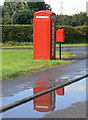
Phone box and pillar box
Both appear to be in good condition, but in fact the telephone box is no longer connected. Although many of these K6 boxes are listed buildings, this one appears not to be.
Image: © Alan Murray-Rust
Taken: 25 Aug 2009
0.16 miles