1
Old Man?s Beard (Clematis vitalba) beside footpath above railway
The waste incinerator chimney can be seen on the horizon
Image: © Luke Shaw
Taken: 28 Jan 2022
0.02 miles
2
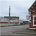
London Road and Eastcroft Incinerator
This view across London Road and the canal from Crocus Street is dominated by the Eastcroft refuse incinerator, whose chimney is a landmark on the south side of the city. Though the principal subject is in
Image, the stretch of London Road and the corrugated-roofed building on the other side of the canal are in
Image and
Image
Image: © John Sutton
Taken: 9 Jun 2012
0.04 miles
3
Carpark of Nottingham Wholesale & Trade Park
View towards Energy from Waste from site of former cattle market
Image: © Roger Templeman
Taken: 1 Jun 2018
0.04 miles
4
Nottingham incinerator
In the foreground is part of the Network Rail permanent way maintenance depot.
Image: © Alan Murray-Rust
Taken: 29 May 2008
0.05 miles
5
Wholesale bread and milk supplies
A small trader's hut on the former cattle market site.
Image: © Alan Murray-Rust
Taken: 29 May 2008
0.05 miles
6
A view from Nottingham Castle
A telephoto view towards the Eastcroft Incinerator and its tall chimney. In the foreground are shops and the Bentinck Hotel on Carrington Street. The railway station is hidden from view. In the distance, to the right of the incinerator, is the brown-brick tower of the new housing development at Trent Basin. The hills near Ratcliffe on Trent are on the skyline to the right, but the Trent Valley and the Vale of Belvoir are lost in the murk of an unseasonably unpleasant June afternoon.
Image: © John Sutton
Taken: 28 Jun 2017
0.05 miles
7
Nottingham Waste Incinerator Facility
Image: © Oxymoron
Taken: 3 Sep 2008
0.05 miles
8
Meadow Lane: in the former cattle market
The café is in what used to be the cattle market offices. In the background is Eastcroft Incinerator, whose chimney is a landmark on the south of the city.
Image: © John Sutton
Taken: 14 Aug 2016
0.06 miles
9
Nottingham incinerator
Viewed from Meadow Lane, from the south east (the incinerator is actually in the neighbouring square). The Midland Railway main line via Oakham and Melton Mowbray used to enter the city roughly here.
Image: © Alan Murray-Rust
Taken: 29 May 2008
0.07 miles
10
Refuse incinerator, Incinerator Road, Nottingham
By John M. Gill, City Engineer, 1970-73. The chimney must be quite a landmark although I don't recall spotting it before I saw the incinerator.
As seen from London Road, in front the Nottingham Canal, and the railway heading east along the southern edge of the city.
Image: © Stephen Richards
Taken: 19 Jun 2012
0.07 miles


