IMAGES TAKEN NEAR TO
Sedbergh Close, NG13 8ZG
Introduction
This page details the photographs taken nearby to Sedbergh Close, NG13 8ZG by members of the Geograph project.
The Geograph project started in 2005 with the aim of publishing, organising and preserving representative images for every square kilometre of Great Britain, Ireland and the Isle of Man.

There are currently over 7.5m images from over14,400 individuals and you can help contribute to the project by visiting https://www.geograph.org.uk
Image Map
Images are licensed for reuse under creativecommons.org/licenses/by-sa/2.0
Notes
- Clicking on the map will re-center to the selected point.
- The higher the marker number, the further away the image location is from the centre of the postcode.
Image Listing (14 Images Found)
Images are licensed for reuse under creativecommons.org/licenses/by-sa/2.0
Image
Details
Distance
1
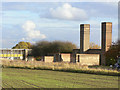
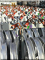
Chimneys at Newton
This appears to have been the central boiler house for the base.
Image: © Alan Murray-Rust
Taken: 23 Oct 2009
0.05 miles
2
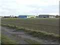
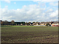
RAF Newton
The two hangars are now occupied by industry. The track in the foreground follows the old airfield perimeter road and at this point is also a public bridleway.
Image: © Alan Murray-Rust
Taken: 23 Oct 2009
0.12 miles
3
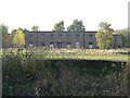
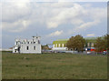
Former RAF Newton
One of the many derelict buildings on the site.
Image: © Alan Murray-Rust
Taken: 23 Oct 2009
0.17 miles
4
Stockyard at Newton
Storage area for one of the firms operating from hangars at the former RAF Newton.
Image: © Alan Murray-Rust
Taken: 23 Oct 2009
0.18 miles
5
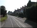
Former RAF Newton
The housing for personnel next to Newton Village is still occupied.
Image: © Alan Murray-Rust
Taken: 23 Oct 2009
0.18 miles
6
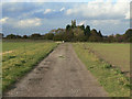
Track across the airfield
This now serves as a public bridleway as well as farm use.
Image: © Alan Murray-Rust
Taken: 23 Oct 2009
0.19 miles

8
Control tower and hangars
A bridleway cuts across the apron of the old airfield giving close up views of the old airfield buildings.
Image: © Alan Murray-Rust
Taken: 23 Oct 2009
0.22 miles
9
Airfield access
This was the main access road to the former RAF Newton. Many of the non-residential buildings have been converted to industrial use, hence the control gate visible.
Image: © Alan Murray-Rust
Taken: 23 Oct 2009
0.22 miles