IMAGES TAKEN NEAR TO
Fosse Road, NOTTINGHAM, NG13 8JB
Introduction
This page details the photographs taken nearby to Fosse Road, NG13 8JB by members of the Geograph project.
The Geograph project started in 2005 with the aim of publishing, organising and preserving representative images for every square kilometre of Great Britain, Ireland and the Isle of Man.

There are currently over 7.5m images from over14,400 individuals and you can help contribute to the project by visiting https://www.geograph.org.uk
Image Map
Images are licensed for reuse under creativecommons.org/licenses/by-sa/2.0
Notes
- Clicking on the map will re-center to the selected point.
- The higher the marker number, the further away the image location is from the centre of the postcode.
Image Listing (21 Images Found)
Images are licensed for reuse under creativecommons.org/licenses/by-sa/2.0
Image
Details
Distance
1
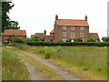
Shackerdale Farm
Built c.1800, a typical brick farmhouse of the period for the area. No longer a farm, with some of the buildings converted to business use. The small building with a chimney stack is a wash house. Listed Grade II.
Image: © Alan Murray-Rust
Taken: 7 Jun 2020
0.01 miles
2
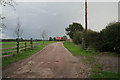
Farm entrance
The entrance to Shackerdale Farm is on the east side of the Image The farm house itself lies on the western corner of Image and Image
Image: © Kate Jewell
Taken: 21 Oct 2006
0.06 miles
3
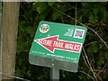
Nature trail walks sign
Based on Home Farm at neighbouring Screveton, which has developed an ecological approach to farming.
Image: © Alan Murray-Rust
Taken: 7 Jun 2020
0.07 miles
4
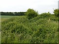
Looking along The Shacker
The stream itself is entirely submerged in bramble growth. The yellow post is a waymarker on the formal line of the footpath which unofficially diverts through the neighbouring gateway.
Image: © Alan Murray-Rust
Taken: 7 Jun 2020
0.15 miles
5
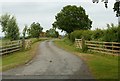
Track to Shackerdale Farm
The farm is no longer in agricultural use.
Image: © Alan Murray-Rust
Taken: 7 Jun 2020
0.16 miles
6
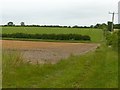
View across Shacker Dale
The Shacker runs along the hedge line. A public footpath runs along the headland.
Image: © Alan Murray-Rust
Taken: 7 Jun 2020
0.16 miles
7
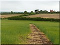
View across Shacker Dale
Looking south. The Shacker runs along the hedge line; Shackerdale Farm in the distance.
Image: © Alan Murray-Rust
Taken: 7 Jun 2020
0.17 miles
8
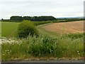
View down Shacker Dale
From the Fosse Way (former A46).
Image: © Alan Murray-Rust
Taken: 7 Jun 2020
0.18 miles
9
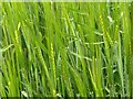
Young barley near Screveton
The ears are beginning to swell. At this stage barley can be identified by colour and the developing awns or whiskers.
Image: © Alan Murray-Rust
Taken: 7 Jun 2020
0.18 miles
10
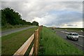
The old and new A46
The southbound carriageway of the old route remains tarmaced.
Image: © David Lally
Taken: 26 Sep 2012
0.18 miles