IMAGES TAKEN NEAR TO
Long Acre, NOTTINGHAM, NG13 8BS
Introduction
This page details the photographs taken nearby to Long Acre, NG13 8BS by members of the Geograph project.
The Geograph project started in 2005 with the aim of publishing, organising and preserving representative images for every square kilometre of Great Britain, Ireland and the Isle of Man.

There are currently over 7.5m images from over14,400 individuals and you can help contribute to the project by visiting https://www.geograph.org.uk
Image Map
Images are licensed for reuse under creativecommons.org/licenses/by-sa/2.0
Notes
- Clicking on the map will re-center to the selected point.
- The higher the marker number, the further away the image location is from the centre of the postcode.
Image Listing (93 Images Found)
Images are licensed for reuse under creativecommons.org/licenses/by-sa/2.0
Image
Details
Distance
1
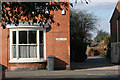
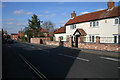
On Church Street
A particularly fine bow window number 19.
Windows with curved glass at 17 and 19 Church Street are a unique in Bingham. One view is that true round bay windows, such as these, were for shops and not houses. John Horsepool the butcher built the houses, so maybe one was his shop too.
Image: © Kate Jewell
Taken: 16 Mar 2010
0.04 miles
2
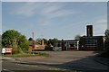
Bingham Fire Station
Bingham Fire Station, Long Acre, Bingham is one of the stations of the Nottinghamshire Fire & Rescue Service
Image: © Kevin Hale
Taken: 29 Apr 2007
0.05 miles
3
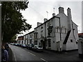
The Chesterfield Arms
On Church Street, Bingham.
Image: © Peter Barr
Taken: 13 Oct 2011
0.05 miles
4
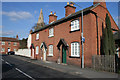
Cottages on Cherry Street
Cherry Street dates back at least as far as the 1841 tithe map and is assumed to derive from one of the orchard crops grown here - orchards lined the west side until 1920.
Image: © Kate Jewell
Taken: 16 Mar 2010
0.05 miles
5
Cherry Street, Bingham
So named because of the fruit orchards that used to be here.
Image: © Kate Jewell
Taken: 16 Mar 2010
0.05 miles
6
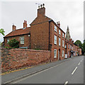
Bingham: Church Street
Brick and pantiles - typical of the east and south of the county.
Image: © John Sutton
Taken: 27 Jun 2017
0.06 miles
7
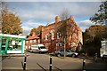
The Manor House
Early 18th century house with later additions in Bingham Market Square, now unoccupied and boarded up
Image: © Richard Croft
Taken: 12 Nov 2008
0.06 miles
8
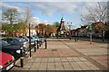
Bingham Market Square
View to the Buttercross in Bingham Market Square
Image: © Richard Croft
Taken: 12 Nov 2008
0.06 miles
9
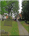
Bingham: churchyard and Church Street
The elaborate lychgate was designed by Frank Miles, the son of the rector, in 1881. The gable on this side is fretted wood. The other side, an iron filigree, is shown in Kate Jewell's Image The picture was taken on a showery and overcast June morning.
Image: © John Sutton
Taken: 27 Jun 2017
0.07 miles
10
The Manor House
Southern elevation of Bingham Manor House http://www.geograph.org.uk/photo/1046045
Image: © Richard Croft
Taken: 12 Nov 2008
0.07 miles