IMAGES TAKEN NEAR TO
Cherry Street, NOTTINGHAM, NG13 8AJ
Introduction
This page details the photographs taken nearby to Cherry Street, NG13 8AJ by members of the Geograph project.
The Geograph project started in 2005 with the aim of publishing, organising and preserving representative images for every square kilometre of Great Britain, Ireland and the Isle of Man.

There are currently over 7.5m images from over14,400 individuals and you can help contribute to the project by visiting https://www.geograph.org.uk
Image Map
Images are licensed for reuse under creativecommons.org/licenses/by-sa/2.0
Notes
- Clicking on the map will re-center to the selected point.
- The higher the marker number, the further away the image location is from the centre of the postcode.
Image Listing (91 Images Found)
Images are licensed for reuse under creativecommons.org/licenses/by-sa/2.0
Image
Details
Distance
1
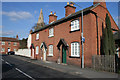
Cottages on Cherry Street
Cherry Street dates back at least as far as the 1841 tithe map and is assumed to derive from one of the orchard crops grown here - orchards lined the west side until 1920.
Image: © Kate Jewell
Taken: 16 Mar 2010
0.01 miles
2
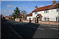
Cherry Street, Bingham
So named because of the fruit orchards that used to be here.
Image: © Kate Jewell
Taken: 16 Mar 2010
0.02 miles
3
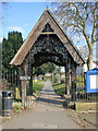
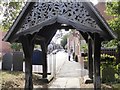
Lych gate, St Mary and All Angels' Church
A fine, decorative example of this ecclesiastical staple.
Image: © Kate Jewell
Taken: 16 Mar 2010
0.03 miles
4
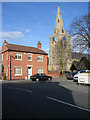
St Mary and All Saints' Church and Church Street
Church Street leads to the Parish Church, but it was called Church Gate in a directory for 1793 and some deed documents of 1692. Gate is the Danish name for a street and is a common name for roads in the old Danelaw areas of Nottinghamshire.
The house straight ahead had a particularly fine boot scraper by the front door constructed of a stone insert with the iron bar fixed across.
Image: © Kate Jewell
Taken: 16 Mar 2010
0.03 miles
5
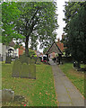
Lychgate at entrance to Bingham church
Looking along Church Street
Image: © David Gearing
Taken: 14 Jul 2017
0.03 miles
6
Bingham: churchyard and Church Street
The elaborate lychgate was designed by Frank Miles, the son of the rector, in 1881. The gable on this side is fretted wood. The other side, an iron filigree, is shown in Kate Jewell's Image The picture was taken on a showery and overcast June morning.
Image: © John Sutton
Taken: 27 Jun 2017
0.03 miles
7
Bingham: passage by the churchyard
This narrow alley runs from East Street to Church Street (ahead). Railings line the south side of the churchyard.
Image: © John Sutton
Taken: 27 Jun 2017
0.03 miles
8
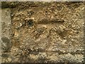
Bench mark and bolt, St Mary's Church, Bingham
Close-up to show the bolt. See http://www.geograph.org.uk/photo/1758627 for location.
Image: © Alan Murray-Rust
Taken: 23 Oct 2016
0.04 miles
9
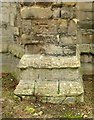
Bench mark and bolt, St Mary's Church, Bingham
Used as a side level on the Coventry to Lincoln levelling line, See http://www.geograph.org.uk/photo/5168146 for close-up and http://www.geograph.org.uk/photo/1758627 for location.
Image: © Alan Murray-Rust
Taken: 23 Oct 2016
0.04 miles
10
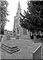
Bingham parish church and churchyard
St Mary and All Saints is mediaeval in origin and was much restored by George Gilbert Scott in 1845-6. The church is hemmed in by houses and trees so photographing its fine tower and spire is difficult.
Image: © John Sutton
Taken: 27 Jun 2017
0.04 miles