IMAGES TAKEN NEAR TO
Bradleys Yard, NOTTINGHAM, NG12 5NR
Introduction
This page details the photographs taken nearby to Bradleys Yard, NG12 5NR by members of the Geograph project.
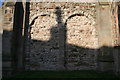
The Geograph project started in 2005 with the aim of publishing, organising and preserving representative images for every square kilometre of Great Britain, Ireland and the Isle of Man.

There are currently over 7.5m images from over14,400 individuals and you can help contribute to the project by visiting https://www.geograph.org.uk
Image Map
Images are licensed for reuse under creativecommons.org/licenses/by-sa/2.0
Notes
- Clicking on the map will re-center to the selected point.
- The higher the marker number, the further away the image location is from the centre of the postcode.
Image Listing (133 Images Found)
Images are licensed for reuse under creativecommons.org/licenses/by-sa/2.0
Image
Details
Distance
1
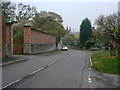
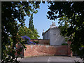
Church Hill
This formed part of the main road between Nottingham and Melton Mowbray until the construction of the bypass in the 1930s. The wall on the left includes the entrance to the stable yard of The Old Rectory and is Listed Grade II.
Image: © Alan Murray-Rust
Taken: 11 Nov 2011
0.05 miles
2
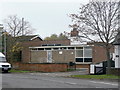
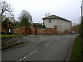
Plumtree Telephone Exchange
This dates from the 1960s and, as it is far larger than the needs of the village, presumably caters for Keyworth and Tollerton as well.
Image: © Alan Murray-Rust
Taken: 11 Nov 2011
0.06 miles
3
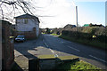
Church Hill, Plumtree
Looking down the street towards Station Road from the corner of the elevated churchyard.
Image: © Kate Jewell
Taken: 24 Jan 2008
0.06 miles
4
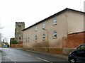
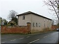
Stable block at The Old Rectory
Early 19th century with some windows with 'Gothick' glazing bars. Now adapted for residential use, Listed Grade II.
Image: © Alan Murray-Rust
Taken: 23 Jan 2022
0.06 miles
5
Old Rectory, Plumtree
Seen from entrance to the public footpath (Plumtree footpath 1) which runs N of the village from Church Hill to Main Street. The Old Rectory is early 19th century and Grade II listed, as are the walls and gateway.
Image: © SK53
Taken: 26 May 2018
0.06 miles
6
Gateway and stable block at the Old Rectory
Both gateway (with adjoining wall) and stable block (also with the adjoining wall beyond) are listed grade II. The stable block retains its original cast iron Gothick window frames.
Image: © Alan Murray-Rust
Taken: 11 Nov 2011
0.06 miles
7
Stable block at The Old Rectory
Early 19th century with some windows with 'Gothick' glazing bars. Now adapted for residential use, Listed Grade II.
Image: © Alan Murray-Rust
Taken: 23 Jan 2022
0.06 miles
8
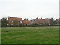
The Poplars
Development of large private houses on the old Poplar Farm farmyard. Note the ridge and furrow strips in the field.
Image: © Alan Murray-Rust
Taken: 11 Nov 2011
0.06 miles
9

The Old Rectory, Plumtree
This end of the house is the earliest section, dating from around 1800. There was a major extension on the far side in the early 19th century. Listed Grade II.
Image: © Alan Murray-Rust
Taken: 23 Jan 2022
0.06 miles
10
Tower detail, St Mary the Virgin, Plumtree
The tower has external Norman blank arcading, original on the south side and a 19th century reconstruction on the north. There is some speculation as to whether the base of the tower was originally open.
Image: © Kate Jewell
Taken: 24 Jan 2008
0.06 miles