IMAGES TAKEN NEAR TO
Belvedere Close, NOTTINGHAM, NG12 5JF
Introduction
This page details the photographs taken nearby to Belvedere Close, NG12 5JF by members of the Geograph project.
The Geograph project started in 2005 with the aim of publishing, organising and preserving representative images for every square kilometre of Great Britain, Ireland and the Isle of Man.

There are currently over 7.5m images from over14,400 individuals and you can help contribute to the project by visiting https://www.geograph.org.uk
Image Map
Images are licensed for reuse under creativecommons.org/licenses/by-sa/2.0
Notes
- Clicking on the map will re-center to the selected point.
- The higher the marker number, the further away the image location is from the centre of the postcode.
Image Listing (24 Images Found)
Images are licensed for reuse under creativecommons.org/licenses/by-sa/2.0
Image
Details
Distance
1
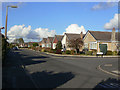
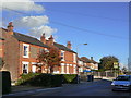
Crossdale Drive
Part of the privately developed sector of Keyworth to the north of the village. View looking north at Franklyn Gardens.
Image: © Alan Murray-Rust
Taken: 1 Nov 2011
0.06 miles
2
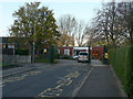
Crossdale Primary School
County Primary School in the northern residential sector of Keyworth.
Image: © Alan Murray-Rust
Taken: 1 Nov 2011
0.10 miles
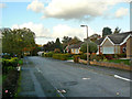
3
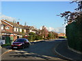
Hillcrest Drive
At the top end of the private housing development at the north west corner of Keyworth.
Image: © Alan Murray-Rust
Taken: 1 Nov 2011
0.13 miles
4
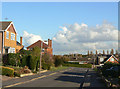
Crossdale Drive
Part of the privately developed sector of Keyworth to the north of the village.
Image: © Alan Murray-Rust
Taken: 1 Nov 2011
0.14 miles
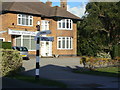
5
Houses on the corner of Debdale Lane
Marking the beginning of the 20th century development of Keyworth away from the traditional village centre.
Image: © Alan Murray-Rust
Taken: 1 Nov 2011
0.14 miles
6
Brookwood Gardens
Still shown as a public footpath on the current OS 1:25000 maps, as it follows the line of an old-established right of way.
Image: © Alan Murray-Rust
Taken: 1 Nov 2011
0.15 miles
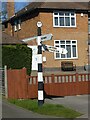
7
Fingerpost at the junction of Nottingham Road and Debdale Lane
The post is a traditional Notts C.C. concrete post with octagonal 'NCC' finial. The fingers are made of plastic rather than the traditional wood, but have applied moulded letters to at least match the style of traditional fingerposts.
Image: © Alan Murray-Rust
Taken: 1 Nov 2011
0.15 miles
8
Fingerpost at the junction of Debdale Lane
A bit wonkier than when I previously photographed it in 2011 https://www.geograph.org.uk/photo/2686981
Image: © Alan Murray-Rust
Taken: 14 Mar 2022
0.15 miles
9
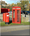
Nottingham Road postbox ref no NG12 152
Current style E II R pillar box outside the Fairway public house. The adjacent K6 telephone kiosk is no longer functioning, and is not listed, but appears to be well maintained.
Image: © Alan Murray-Rust
Taken: 1 Nov 2011
0.15 miles
10
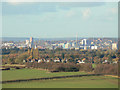
View to Nottingham
Some 8 kilometres distant in and around Image The tall chimney is the refuse incinerator; the tallest building towards the left is Victoria Centre Flats.
Image: © Alan Murray-Rust
Taken: 1 Nov 2011
0.15 miles