IMAGES TAKEN NEAR TO
Pinfold Lane, NOTTINGHAM, NG12 5EZ
Introduction
This page details the photographs taken nearby to Pinfold Lane, NG12 5EZ by members of the Geograph project.
The Geograph project started in 2005 with the aim of publishing, organising and preserving representative images for every square kilometre of Great Britain, Ireland and the Isle of Man.

There are currently over 7.5m images from over14,400 individuals and you can help contribute to the project by visiting https://www.geograph.org.uk
Image Map
Images are licensed for reuse under creativecommons.org/licenses/by-sa/2.0
Notes
- Clicking on the map will re-center to the selected point.
- The higher the marker number, the further away the image location is from the centre of the postcode.
Image Listing (131 Images Found)
Images are licensed for reuse under creativecommons.org/licenses/by-sa/2.0
Image
Details
Distance
1
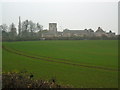
View of Plumtree
From Cotgrave Road on a murky November afternoon.
Image: © Alan Murray-Rust
Taken: 11 Nov 2011
0.02 miles
2
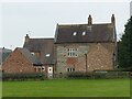
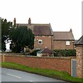
Hall Farmhouse, west front
The stone section dates from the early 17th century, with much of the rest of the house from the mid 18th century. Listed Grade II.
Image: © Alan Murray-Rust
Taken: 23 Jan 2022
0.02 miles
3
Hall Farmhouse and Plumtree Church
This view shows the rear of Hall Farmhouse http://www.geograph.org.uk/photo/2696205 with its fine 17th century stone mullioned windows.
Image: © Alan Murray-Rust
Taken: 11 Nov 2011
0.02 miles
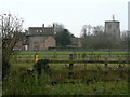
4
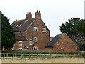
Manor Farm
Farming activity has ceased here, with the ranges of farm buildings converted to or replaced by residential accommodation. The farm house itself dates from the early 17th century http://www.geograph.org.uk/photo/2696584, but the front seen here is mid 18th century, in typical local style. Listed Grade II.
Image: © Alan Murray-Rust
Taken: 11 Nov 2011
0.02 miles
5
Hall Farmhouse, Plumtree, east front
This side of the house consists largely of early 18th century enlargement of an earlier 17th century house https://www.geograph.org.uk/photo/7080136 . Listed Grade II.
Image: © Alan Murray-Rust
Taken: 23 Jan 2022
0.02 miles
6
Hall Farmhouse, south front
This section of the house dates from the mid 18th century. Listed Grade II. The outbuilding is an early 21st century garage.
Image: © Alan Murray-Rust
Taken: 23 Jan 2022
0.03 miles
7
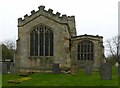
Church of St Mary, Plumtree
The east end. The north aisle window is 15th century, moved from the chancel during the rebuilding of the 1870s, when the new, larger, east window was inserted. Listed Grade I.
Image: © Alan Murray-Rust
Taken: 23 Jan 2022
0.04 miles
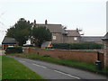
8
Pinfold Lane, Plumtree
Although a private road, the road sign has been provided by the local authority.
Image: © Alan Murray-Rust
Taken: 11 Nov 2011
0.04 miles
9
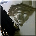
Church of St Mary, Plumtree
North chancel arch respond, featuring an animal head (fox?) on the corbel. 13th century, Early English.
Image: © Alan Murray-Rust
Taken: 23 Jan 2022
0.04 miles
10
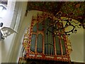
Church of St Mary, Plumtree
The organ was installed in 1880 and was the gift of William Elliott Burnside, a relative of the Rector, William Burnside. It was made by Wordsworth and Maskell, of Leeds. The very ornate, painted and gilded, organ case was designed by Revd Frederick H Sutton while he was Rector of Brant Broughton, Lincolnshire, birthplace of Revd William Burnside’s wife Fanny. The decoration accords with the other decorations of the chancel from the 1870s restoration.
Image: © Alan Murray-Rust
Taken: 23 Jan 2022
0.04 miles