IMAGES TAKEN NEAR TO
Jubilee Road, NOTTINGHAM, NG12 4JZ
Introduction
This page details the photographs taken nearby to Jubilee Road, NG12 4JZ by members of the Geograph project.
The Geograph project started in 2005 with the aim of publishing, organising and preserving representative images for every square kilometre of Great Britain, Ireland and the Isle of Man.

There are currently over 7.5m images from over14,400 individuals and you can help contribute to the project by visiting https://www.geograph.org.uk
Image Map
Images are licensed for reuse under creativecommons.org/licenses/by-sa/2.0
Notes
- Clicking on the map will re-center to the selected point.
- The higher the marker number, the further away the image location is from the centre of the postcode.
Image Listing (30 Images Found)
Images are licensed for reuse under creativecommons.org/licenses/by-sa/2.0
Image
Details
Distance
1
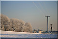
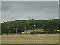
Sharphill Wood and Roberts Farm
Everything covered in a thick hoar frost, including the power lines.
Image: © David Lally
Taken: 7 Dec 2010
0.04 miles
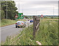
2
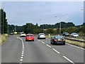
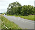
Nottingham - NG2 (A52)
A view from the closed end of Landmere Lane (a cul-de-sac) looking towards Melton Road (the A606). This lane was chopped into two (when ?) by the construction of the A52, a dual carriageway on the right of the photographer. A small business park now exists at this end of the lane, as does the popular Wheatcroft Garden Centre that is located behind the trees beyond the flag pole. The lane itself peters out on the left, leading into a large car park and to nearby Roberts Farm.
Image: © David Hallam-Jones
Taken: 9 Jun 2012
0.13 miles
3
Landmere Lane
The nearer roadway is part of the old Landmere Lane, now superseded by the A52 Ring Road. The old rural character has been completely lost - this section now sports a small business park.
Image: © Alan Murray-Rust
Taken: 23 Sep 2008
0.14 miles

5
Nottingham - NG2 (A52)
A section of the A52 near the Wheatcroft Garden Centre as it nears the Tollerton Roundabout (both out of sight of the photographer). Landmere Lane, on the right - where a business park building and some railings can be just about be seen - used to cross the carriageway at the point where the oncoming lorry is, until this main road was constructed.
Image: © David Hallam-Jones
Taken: 9 Jun 2012
0.15 miles
6
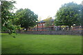
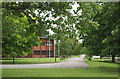
Lawn by Clifton Boulevard, Edwalton
By Clifton Boulevard
Image: © David Howard
Taken: 8 May 2022
0.15 miles
7
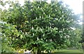
Chestnut tree by Clifton Boulevard, Edwalton
Image: © David Howard
Taken: 8 May 2022
0.15 miles
8
A52 and Sharphill Wood
From the bridleway to Ruddington.
Image: © Alan Murray-Rust
Taken: 23 Sep 2008
0.16 miles
9
Nottingham - NG2 (A52)
A section of the A52 as it nears the Tollerton Roundabout. Landmere Lane, the location of Wheatcroft Garden Centre, runs parallel with the A52 on the left-hand side of this carriageway (albeit out of sight behind the trees). Landmere Lane was chopped into two when the A52 was constructed although the route of a permissive bridleway still crosses the dual carriageway here in between where these last two cars are positioned. The path then follows the line of this central fence before crossing the other half of the carriageway and continuing across along the edge of an adjacent field.
Image: © David Hallam-Jones
Taken: 9 Jun 2012
0.16 miles