IMAGES TAKEN NEAR TO
Zambra Court, NOTTINGHAM, NG12 4GF
Introduction
This page details the photographs taken nearby to Zambra Court, NG12 4GF by members of the Geograph project.
The Geograph project started in 2005 with the aim of publishing, organising and preserving representative images for every square kilometre of Great Britain, Ireland and the Isle of Man.

There are currently over 7.5m images from over14,400 individuals and you can help contribute to the project by visiting https://www.geograph.org.uk
Image Map
Images are licensed for reuse under creativecommons.org/licenses/by-sa/2.0
Notes
- Clicking on the map will re-center to the selected point.
- The higher the marker number, the further away the image location is from the centre of the postcode.
Image Listing (37 Images Found)
Images are licensed for reuse under creativecommons.org/licenses/by-sa/2.0
Image
Details
Distance
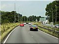
1
Approach to the Ring Road roundabout
Looking down the Melton Road. This was de-trunked following the opening of the Lings Bar Road - the first exit left from this direction.
Image: © Alan Murray-Rust
Taken: 23 Sep 2008
0.07 miles
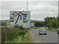
2

Road to the A606
Leading from a local Garden Centre to the A606.
Image: © J.Hannan-Briggs
Taken: 2 Feb 2013
0.08 miles
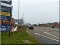
3

Nottingham - NG12 (Melton Rd)
The entrance/exit to Landmere Lane, off Melton Road (the A606). This cul-de-sac is used by motorists visiting the popular Wheatcroft Garden Centre that is located at the far end of it. "Toll Bar House", that was previously situated behind the fence on the right-hand side of this picture (marked on the 2007 version of the Nottingham A-Z Street Atlas) seems to have been demolished and in its place is a concrete standing area where large quantities of top soil are being stored.
Image: © David Hallam-Jones
Taken: 9 Jun 2012
0.08 miles
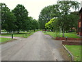
4
The junction into Landmere Lane off Melton Road
What used to be little more than a farm track is now the access to a substantial commercial development.
Image: © Alan Murray-Rust
Taken: 23 Jan 2022
0.09 miles
5

Landmere Lane
What used to be little more than a farm track is now the access to a substantial commercial development. The building on the left is Toll Bar House, a reminder of the presence of a toll bar at this location in years past. Compare with the same location 10 years earlier https://www.geograph.org.uk/photo/2988280
Image: © Alan Murray-Rust
Taken: 23 Jan 2022
0.09 miles
6
Nottingham - NG2 (Melton Rd)
The closed end of the Landmere Lane cul-de-sac, off Melton Road (the A606). Landmere Lane was longer previously but it was chopped into two (when ?) by the construction of the A52, a dual carriageway. Once past the popular Wheatcroft Garden Centre at this end of the lane (behind & slightly to the right of the photographer) a small business park is to be found adjacent to the site of Roberts Farm.
Image: © David Hallam-Jones
Taken: 9 Jun 2012
0.11 miles
7
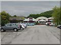
Wheatcrofts Garden Centre
Once home of the famous roses, it has passed out of the hands of the Wheatcroft family, although the name is retained. Viewed from the footpath past the car park (which is now further east than is shown on either the 1:50000 or 1:25000 maps).
Image: © Alan Murray-Rust
Taken: 23 Sep 2008
0.12 miles
8
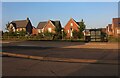
Melton Road, Edwalton
Looking towards the new houses on Hemlock Road.
Image: © David Howard
Taken: 8 May 2022
0.12 miles
9
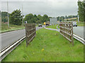
Bridleway crossing
The fences act partly as barriers to prevent a straight crossing of the dual carriageway, but also afford some protection to equestrians making the crossing.
Image: © Alan Murray-Rust
Taken: 23 Sep 2008
0.14 miles