IMAGES TAKEN NEAR TO
Kinoulton Lane, NOTTINGHAM, NG12 3UG
Introduction
This page details the photographs taken nearby to Kinoulton Lane, NG12 3UG by members of the Geograph project.
The Geograph project started in 2005 with the aim of publishing, organising and preserving representative images for every square kilometre of Great Britain, Ireland and the Isle of Man.

There are currently over 7.5m images from over14,400 individuals and you can help contribute to the project by visiting https://www.geograph.org.uk
Image Map
Images are licensed for reuse under creativecommons.org/licenses/by-sa/2.0
Notes
- Clicking on the map will re-center to the selected point.
- The higher the marker number, the further away the image location is from the centre of the postcode.
Image Listing (10 Images Found)
Images are licensed for reuse under creativecommons.org/licenses/by-sa/2.0
Image
Details
Distance
1
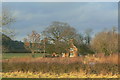
Woodman's Cottage
A typical estate cottage of the 19th century.
Image: © Alan Murray-Rust
Taken: 9 Jan 2011
0.01 miles
2
Chestnut Tree on Kinoulton Lane
looks like it will be a good season for konkers
Image: © Tom Courtney
Taken: 18 Sep 2005
0.04 miles
3
Herrywell Lane
The eastern end of a long byway which ends up near Cotgrave. Currently partly closed as a right of way due to the reconstruction of the A46 which runs at the back of the woodland.
Image: © Alan Murray-Rust
Taken: 9 Jan 2011
0.09 miles
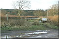
5
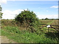
Four squares
Four squares meet here. The notice on the gate concerns proposals to divert footpaths in this area.
Image: © Jonathan Thacker
Taken: 23 Sep 2016
0.12 miles
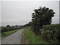
7
Herrywell Lane
Now a restricted byway but its width suggests it was once a significant road, possibly a turnpike?
Image: © Graham Hogg
Taken: 28 Feb 2017
0.16 miles
8
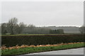
A grey day between Kinoulton and Cropwell Bishop
Taken opposite Mackley's Farm, looking towards Borders Wood, in deteriorating weather conditiond.
Gusts of 108 mph have hit Wales and a Met. Office Red Warning for hurricane force winds is in force, and a cold front is in the process of trundling through this area, making even getting out of the car a dangerous business!
All that in a winter that has been the wettest for about 200 years, with the Somerset levels underwater for nearly two months, and the Thames has burst its banks and is at its highest level for 60 years.
Image: © Chris
Taken: 12 Feb 2014
0.17 miles
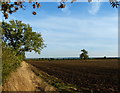
9
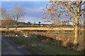
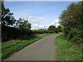
View from Kinoulton Lane
Looking towards the village of Owthorpe.
Image: © Alan Murray-Rust
Taken: 9 Jan 2011
0.18 miles
10
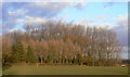
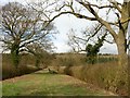
Plantation near Owthorpe
These trees surround a series of ponds which appear to be a private fishing area.
Image: © Alan Murray-Rust
Taken: 9 Jan 2011
0.21 miles