IMAGES TAKEN NEAR TO
Meadow Way, NOTTINGHAM, NG12 3RE
Introduction
This page details the photographs taken nearby to Meadow Way, NG12 3RE by members of the Geograph project.
The Geograph project started in 2005 with the aim of publishing, organising and preserving representative images for every square kilometre of Great Britain, Ireland and the Isle of Man.

There are currently over 7.5m images from over14,400 individuals and you can help contribute to the project by visiting https://www.geograph.org.uk
Image Map
Images are licensed for reuse under creativecommons.org/licenses/by-sa/2.0
Notes
- Clicking on the map will re-center to the selected point.
- The higher the marker number, the further away the image location is from the centre of the postcode.
Image Listing (62 Images Found)
Images are licensed for reuse under creativecommons.org/licenses/by-sa/2.0
Image
Details
Distance
1
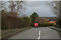
Meadow Way
For the moment, at least, there are still meadows at the end of it.
Image: © Chris
Taken: 12 Feb 2014
0.06 miles
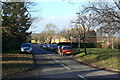
2
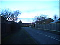
Meadow Way, Kinoulton
A residential road off Main Street.
Image: © Richard Vince
Taken: 10 Jan 2016
0.07 miles
3
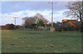
Field behind Newbold Way, Kinoulton
The ridge and furrow pattern shows that this was part of the mediaeval field system, which has been cut into by the modern housing development.
Image: © Alan Murray-Rust
Taken: 9 Jan 2011
0.08 miles
4
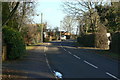
Kinoulton, Main Street
Looking east from near Pinfold Lane.
Image: © Alan Murray-Rust
Taken: 9 Jan 2011
0.08 miles
5
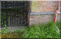
Bench mark, former Methodist Chapel, Kinoulton
See http://www.geograph.org.uk/photo/3958195 for location.
Image: © Alan Murray-Rust
Taken: 27 Apr 2014
0.09 miles
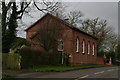
6
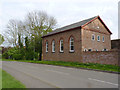
The Old Methodist Chapel, Main Street, Kinoulton
Built in 1878, now converted into residential accommodation.
There is a bench mark http://www.geograph.org.uk/photo/3958198 on the far corner of the building.
Image: © Alan Murray-Rust
Taken: 27 Apr 2014
0.10 miles
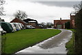
9
Pinfold Lane, Kinoulton
This looks like a council development of the 1950s. There is no sign of the pinfold, although several villages in the area still have one.
Image: © Alan Murray-Rust
Taken: 9 Jan 2011
0.12 miles
10
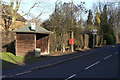
Pinfold Lane bus stop
Currently unserved as the road is closed as a through route due to the reconstruction of the A46. The postbox is ref NG12 215, Main Street (East end).
Image: © Alan Murray-Rust
Taken: 9 Jan 2011
0.12 miles