IMAGES TAKEN NEAR TO
Pinfold Close, NOTTINGHAM, NG12 3EW
Introduction
This page details the photographs taken nearby to Pinfold Close, NG12 3EW by members of the Geograph project.
The Geograph project started in 2005 with the aim of publishing, organising and preserving representative images for every square kilometre of Great Britain, Ireland and the Isle of Man.

There are currently over 7.5m images from over14,400 individuals and you can help contribute to the project by visiting https://www.geograph.org.uk
Image Map
Images are licensed for reuse under creativecommons.org/licenses/by-sa/2.0
Notes
- Clicking on the map will re-center to the selected point.
- The higher the marker number, the further away the image location is from the centre of the postcode.
Image Listing (46 Images Found)
Images are licensed for reuse under creativecommons.org/licenses/by-sa/2.0
Image
Details
Distance
2
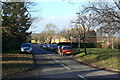
Pinfold Lane, Kinoulton
This looks like a council development of the 1950s. There is no sign of the pinfold, although several villages in the area still have one.
Image: © Alan Murray-Rust
Taken: 9 Jan 2011
0.04 miles
3
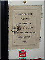
19th century cupboard, Kinoulton Church
Cast in iron with the names of the incumbent and churchwardens and dated 1813.
Image: © Alan Murray-Rust
Taken: 27 Apr 2014
0.05 miles
4
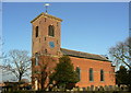
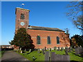
St Luke's Church, Kinoulton
It's relatively rare to find a village parish church dating from as late as 1793. The previous church was not on the same site, but up on the wolds. The graveyard still exists http://www.geograph.org.uk/photo/430764 . Surprisingly, the dedication was not retained, and the one chosen is the same as in the next door village of Hickling. The current church is Listed Grade II*.
There is a bench mark http://www.geograph.org.uk/photo/3958199 on the near corner of the tower.
Image: © Alan Murray-Rust
Taken: 9 Jan 2011
0.05 miles
5
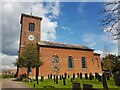
Church of St Luke, Kinoulton
Unusual for this area, where most villages have retained their medieval churches, this Georgian church "was built by the Earl of Gainsborough in 1792-93 to replace the medieval church of St Wilfrid’s which was inconveniently located 3 km to the west, near the Fosse Way, and was demolished in the late 18th century." http://nottshistoricchurchtrust.org.uk/church-of-the-month-nov-2/
Image: © Tim Heaton
Taken: 30 Apr 2021
0.05 miles
6
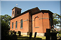
St.Luke's church
Red brick Georgian church of 1793
Image: © Richard Croft
Taken: 9 Jul 2013
0.05 miles
7
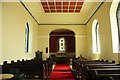
St.Luke's nave
Looking east towards the small apsidal chancel in St.Luke's church http://www.geograph.org.uk/photo/3549525
Image: © Richard Croft
Taken: 9 Jul 2013
0.05 miles
8
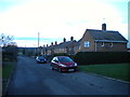
Pinfold Lane, Kinoulton
A residential cul de sac off Main Street.
Image: © Richard Vince
Taken: 10 Jan 2016
0.05 miles
9
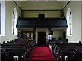
St Luke's Church, Kinoulton, looking west
The gallery would have been the traditional place for the village band to play during church services. The original box pews were replaced by bench pews in 1858, so the full impression of an 18th century church interior has been lost. Some of these have since been removed to create a children's area.
Image: © Alan Murray-Rust
Taken: 27 Apr 2014
0.05 miles
10
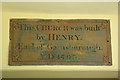
Dedication plaque
Dedication in St.Luke's church http://www.geograph.org.uk/photo/3549525 acknowledging the benefaction of Henry, Earl of Gainsborough
Image: © Richard Croft
Taken: 9 Jul 2013
0.06 miles