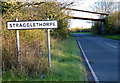
IMAGES TAKEN NEAR TO
Stragglethorpe, Radcliffe-on-Trent, NOTTINGHAM, NG12 2JZ
Introduction
This page details the photographs taken nearby to NG12 2JZ by members of the Geograph project.
The Geograph project started in 2005 with the aim of publishing, organising and preserving representative images for every square kilometre of Great Britain, Ireland and the Isle of Man.

There are currently over 7.5m images from over14,400 individuals and you can help contribute to the project by visiting https://www.geograph.org.uk
Image Map
Images are licensed for reuse under creativecommons.org/licenses/by-sa/2.0
Notes
- Clicking on the map will re-center to the selected point.
- The higher the marker number, the further away the image location is from the centre of the postcode.
Image Listing (30 Images Found)
Images are licensed for reuse under creativecommons.org/licenses/by-sa/2.0
Image
Details
Distance
1
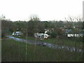
Thorntons Holt
Caravan camping park near Cotgrave. Formerly this was an area of woodland, as the name indicates.
Image: © Alan Murray-Rust
Taken: 13 Dec 2009
0.01 miles
2
Bridge over Stragglethorpe Road
The former railway branch to Cotgrave Colliery, now converted to a bridleway linking Radcliffe to Cotgrave Country Park. It opened in April 2019.
Image: © Alan Murray-Rust
Taken: 30 Apr 2020
0.07 miles
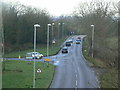
3
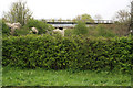
Railway Bridge near Stragglethorpe
This railway line opened in the 1960s to carry coal from Cotgrave Colliery, one of the last pits to be sunk, in 1964. The coal was carried north west to the main Nottingham to Grantham line and the Colwick marshalling yard: see Image, Image and Image When Cotgrave closed in 1994 there were millions of tonnes in reserves but the coal was not of the highest quality, and it was deemed uneconimic to extract.
(Caption amended based on information provided by John Sutton http://www.geograph.org.uk/profile/38492 )
Image: © Kate Jewell
Taken: 30 Apr 2006
0.08 miles
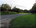
6
Shepherd's House junction
The road to Cotgrave turns off to the left. The main road is Stragglethorpe Lane and was substantially improved in the 1950s when Cotgrave Colliery was developed.
Image: © Alan Murray-Rust
Taken: 13 Dec 2009
0.11 miles
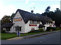
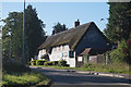
8
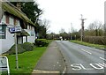
Shepherd's, near Stragglethorpe, Nottinghamshire
Recreating this 'First' for the square https://www.geograph.org.uk/photo/161588 . The restaurant is now known as 'The Shepherds'.
Image: © Alan Murray-Rust
Taken: 1 Jan 2022
0.12 miles
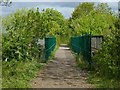
10
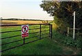
Footpath from Stragglethorpe Road towards Radcliffe on Trent
Image: © Andrew Tatlow
Taken: 23 Jul 2019
0.14 miles