IMAGES TAKEN NEAR TO
Hollowstone, NOTTINGHAM, NG1 1JH
Introduction
This page details the photographs taken nearby to Hollowstone, NG1 1JH by members of the Geograph project.
The Geograph project started in 2005 with the aim of publishing, organising and preserving representative images for every square kilometre of Great Britain, Ireland and the Isle of Man.

There are currently over 7.5m images from over14,400 individuals and you can help contribute to the project by visiting https://www.geograph.org.uk
Image Map
Images are licensed for reuse under creativecommons.org/licenses/by-sa/2.0
Notes
- Clicking on the map will re-center to the selected point.
- The higher the marker number, the further away the image location is from the centre of the postcode.
Image Listing (1338 Images Found)
Images are licensed for reuse under creativecommons.org/licenses/by-sa/2.0
Image
Details
Distance
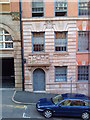
3
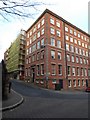
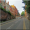
Hollowstone and St Mary's churchyard wall
The churchyard is to the left, at a higher level than High Pavement. The gradients of this coach and waggon route out of the city were eased in the 18th century. The tall warehouses on Hollowstone are typical of The Lace Market. For more on the history of Hollowstone, see http://www.nottshistory.org.uk/articles/tts/tts1927/itinerary1927p1.htm and http://www.nottshistory.org.uk/articles/tts/tts1927/itinerary1927p2.htm .
Image: © John Sutton
Taken: 30 Apr 2013
0.01 miles
4
Hollowstone
The name is derived from the caves in the soft yellow Bunter sandstone outcrop on which the old town was built. Tens if not hundreds of caves are known, and new ones are still being discovered.
Image: © Alan Murray-Rust
Taken: 11 Feb 2007
0.01 miles
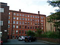
5
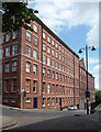
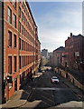
Hollowstone, Nottingham
Short street whose north side is lined with huge former warehouses. The corner one is by F. Williamson, 1873, next door with a shaped gable is by W. Dymock Pratt, 1904, and the furthest one is by Sutton & Gregory, 1908. All grade II listed.
I think they've all been converted to flats.
Image: © Stephen Richards
Taken: 18 Jun 2012
0.01 miles
6
A stroll round Nottingham City Centre (27)
(junction of Stoney Street and Short Hill, Nottingham)
Image: © Basher Eyre
Taken: 2 Dec 2018
0.01 miles
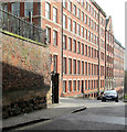
7
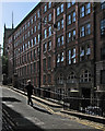
Up Hollowstone (or Hollow Stone)
Tall former lace warehouses seen from the corner of Short Stairs on a very bright August afternoon. The man is walking up Short Hill - the less steeply graded Hollowstone is beyond and below the railings.
Image: © John Sutton
Taken: 8 Aug 2016
0.01 miles
8
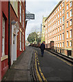
Short Hill, St Mary's and Hollowstone
Hollowstone, to the right, is at a lower level, the result of the gradient being eased in the 18th century, when it became the main coach route into the city from the east. Both streets lead to High Pavement and St Mary's Church, in the centre of The Lace Market. For more of the history of this area, see http://www.nottshistory.org.uk/articles/tts/tts1927/itinerary1927p2.htm .
Image: © John Sutton
Taken: 30 Apr 2013
0.01 miles
9
Up Hollowstone to High Pavement
Hollowstone (or Hollow Stone) was once the main route into the centre of Nottingham from the east. The flight of steps half way up on the left leads to Short Hill, where new student accommodation is being built on a former car park - see Image], which has links to earlier pictures.
Image: © John Sutton
Taken: 22 Sep 2021
0.01 miles
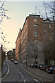
10
Down Hollowstone
This was once the main route into the centre of Nottingham from the east, and the road level was lowered in the eighteenth century to ease the passage of horse-drawn wagons. Short Hill, in shadow on the right, shows the original road level. In the nineteenth century huge warehouses like the one on the left (now student flats) were built all over the Lace Market. The bright light of an April morning shows just how orange Nottingham-made brick is.
The picture was taken from St Mary's churchyard: Image] is the view up Hollowstone (or Hollow Stone) from Short Hill.
Image: © John Sutton
Taken: 22 Apr 2015
0.02 miles