IMAGES TAKEN NEAR TO
Cliff Road, NOTTINGHAM, NG1 1GY
Introduction
This page details the photographs taken nearby to Cliff Road, NG1 1GY by members of the Geograph project.
The Geograph project started in 2005 with the aim of publishing, organising and preserving representative images for every square kilometre of Great Britain, Ireland and the Isle of Man.

There are currently over 7.5m images from over14,400 individuals and you can help contribute to the project by visiting https://www.geograph.org.uk
Image Map
Images are licensed for reuse under creativecommons.org/licenses/by-sa/2.0
Notes
- Clicking on the map will re-center to the selected point.
- The higher the marker number, the further away the image location is from the centre of the postcode.
Image Listing (1717 Images Found)
Images are licensed for reuse under creativecommons.org/licenses/by-sa/2.0
Image
Details
Distance
1
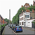
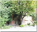
Cliff Road and The Loggerheads
The council houses of Cliff Road, over which the sandstone bluff on which the Lace Market district stands looms, were built on the site of one of the city's most notorious slums, Narrow Marsh. The Loggerheads, now closed, used to have a nine-pin skittle alley.
Image: © John Sutton
Taken: 24 Aug 2015
0.00 miles
2
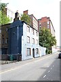
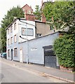
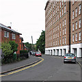
Cliff Road, Nottingham, NG1
Cliff Road, formerly Narrow Marsh, is situated at the foot of St. Mary's Cliff and as such is also within the Lace Market Conservation Area. The building in the centre of the picture is the former Loggerheads public house, an establishment that has not functioned as such for over 10 years. Planning permission is currently being sought for its conversion into nine apartments. St Mary’s Cliff is a distinctive landscape feature, sections of which have been reinforced with brick retaining walls to preserve properties on High Pavement above and behind it. On April 13th, 1828, a mass of rock and some brickwork, that had previously been part of a summer house, came cascading down crushing five houses adjoining the pub. One family who happened still to be in their home at the time of the accident escaped injury. In the distance former mill buildings associated with lace finishing processes were converted into apartments a number of years ago.
Image: © David Hallam-Jones
Taken: 13 Sep 2020
0.01 miles
3
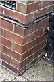
Benchmark on #40 Cliff Road
Ordnance Survey cut mark benchmark described on the Bench Mark Database at http://www.bench-marks.org.uk/bm34419
Image: © Roger Templeman
Taken: 11 Apr 2012
0.01 miles
4
#40 Cliff Road
There is an OS benchmark Image on the front of the house near the left hand side corner
Image: © Roger Templeman
Taken: 11 Apr 2012
0.01 miles
5
Cliff Road, Nottingham, NG1
A tiny public garden or recreational area situated at the foot of St. Mary's Cliff between the former Loggerheads public house (not seen here but situated on the left) and some former mill buildings once associated with lace finishing processes that were converted into apartments a number of years ago. On the south side of the street, i.e. behind the photographer, are row of traditional local authority owned housing, c.1950s. This street was known as Narrow Marsh in the distant past and later renamed Red Lion Street. Following an extensive clearance of slum housing on the street in 1933 it was renamed Cliff Road.
Image: © David Hallam-Jones
Taken: 13 Sep 2020
0.01 miles
6
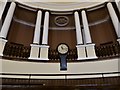
A stroll round Nottingham City Centre (33)
Inside the National Justice Museum http://www.nationaljusticemuseum.org.uk/
Image: © Basher Eyre
Taken: 2 Dec 2018
0.02 miles
7
Cliff Road, Nottingham, NG1
A view of the former Loggerheads public house located below St Mary’s Cliff with glimpses of other properties that are also in the Lace Market Conservation Area behind it. The pub has been closed for more than 10 years and it is currently awaiting planning permission for conversion into nine apartments. On the south side of the street, i.e. on the photographer’s left, are a row of traditional local authority owned housing, c.1950s.
Image: © David Hallam-Jones
Taken: 13 Sep 2020
0.02 miles
8
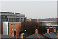
Over Narrow Marsh
A spring-morning view from Malin Hill. The roofs in the foreground are of houses on Cliff Road. The NET tramway crosses the picture on the right, on the alignment of the old Great Central Railway.
Image: © John Sutton
Taken: 11 Apr 2016
0.02 miles
9
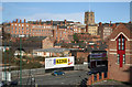
Undercliff
Mixed housing and industrial development nestles below the high ground on which Nottingham's Lace Market, surrounding St Mary's Church, stands.
Image: © Alan Murray-Rust
Taken: 21 Jan 2007
0.02 miles
10
Along Cliff Road
Before the council houses on the left were built, this was Narrow Marsh, one of Nottingham's worst slums.
Image: © John Sutton
Taken: 24 Aug 2015
0.02 miles