IMAGES TAKEN NEAR TO
Carter Gate, NOTTINGHAM, NG1 1GL
Introduction
This page details the photographs taken nearby to Carter Gate, NG1 1GL by members of the Geograph project.
The Geograph project started in 2005 with the aim of publishing, organising and preserving representative images for every square kilometre of Great Britain, Ireland and the Isle of Man.

There are currently over 7.5m images from over14,400 individuals and you can help contribute to the project by visiting https://www.geograph.org.uk
Image Map
Images are licensed for reuse under creativecommons.org/licenses/by-sa/2.0
Notes
- Clicking on the map will re-center to the selected point.
- The higher the marker number, the further away the image location is from the centre of the postcode.
Image Listing (950 Images Found)
Images are licensed for reuse under creativecommons.org/licenses/by-sa/2.0
Image
Details
Distance
1
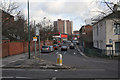
The Gates of Nottingham (5)
Fishergate
Nottingham has nearly 20 streets incorporating the Norse-derived 'Gate', meaning a thoroughfare, not a barrier.
Next in series Image
Image: © Alan Murray-Rust
Taken: 11 Feb 2007
0.00 miles
2
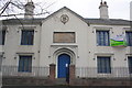
Plumtre Hospital, now 'character offices'
There should be an Ordnance Survey cut mark benchmark, http://www.bench-marks.org.uk/bm34316 on the front of the jut left of the door, but the building has been redered concealling the mark.
Image: © Roger Templeman
Taken: 1 Apr 2013
0.04 miles
3
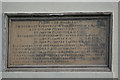
Plumptre Hospital commemorative panel
This is the stone panel which can be seen above the doorway in Image
Image: © Alan Murray-Rust
Taken: 27 Jan 2008
0.04 miles
4
Plumptre Hospital
This was a foundation for a 'Master and 13 poor widows' dating back to 1392, the present building dating from 1823. The patronage had remained with the Plumptre family for the whole of this time, as related on the stone above the doorway.
The charity remained in the premises until 1991, after which it stood vacant for 10 years. Since then it has been the RNIB Employment and Education Centre, so it is still providing assistance to disadvantaged people.
A close-up of the plaque can be seen here Image
Image: © Alan Murray-Rust
Taken: 27 Jan 2008
0.04 miles
5
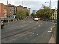
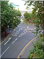
Hollowstone
The street gets its name from the fact that it was originally hollowed out of the Bunter sandstone on which Nottingham stands. Behind the photographer the outcropping rock with a number of incised caves is still exposed.
Image: © Alan Murray-Rust
Taken: 27 Jan 2008
0.05 miles
6
Hollow Stone
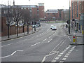
A busy three lane one-way road. Part of Nottingham's inner ring road. This heads north into the city centre as the A6008. The outward - southbound - route is by Lower Parliament Street to the east.
Image: © David Lally
Taken: 5 May 2015
0.05 miles
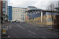
8
Chardlace Walk
The Saxon burgh which became Nottingham developed at the top of a sandstone cliff which overlooked the meadows north of the River Trent (and at that time the course of the River Leen, a tributary of the Trent, since culverted and diverted). This recent development at the base of the cliff, between Hollowstone and Malin Hill (ahead) makes a feature of the sandstone outcrop on the right.
Image: © John Sutton
Taken: 22 Sep 2021
0.05 miles
9
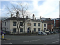
Junction of Hollowstone and Bellar Gate
Image: © Andrew Abbott
Taken: 12 Jun 2010
0.05 miles
10
The Gates of Nottingham (2)
Bellar Gate
Nottingham has nearly 20 streets incorporating the Norse-derived 'Gate', meaning a thoroughfare, not a barrier.
Next in series Image
Image: © Alan Murray-Rust
Taken: 11 Feb 2007
0.05 miles