IMAGES TAKEN NEAR TO
Chancery Court, NOTTINGHAM, NG11 7EQ
Introduction
This page details the photographs taken nearby to Chancery Court, NG11 7EQ by members of the Geograph project.
The Geograph project started in 2005 with the aim of publishing, organising and preserving representative images for every square kilometre of Great Britain, Ireland and the Isle of Man.

There are currently over 7.5m images from over14,400 individuals and you can help contribute to the project by visiting https://www.geograph.org.uk
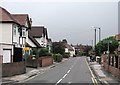
Image Map
Images are licensed for reuse under creativecommons.org/licenses/by-sa/2.0
Notes
- Clicking on the map will re-center to the selected point.
- The higher the marker number, the further away the image location is from the centre of the postcode.
Image Listing (143 Images Found)
Images are licensed for reuse under creativecommons.org/licenses/by-sa/2.0
Image
Details
Distance
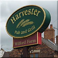
1
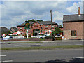
Harvester
Former stables block belonging to Wilford House converted into a pub-restaurant.
Image: © Alan Murray-Rust
Taken: 29 May 2009
0.02 miles
3
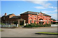
Harvester Restaurant
On Clifton Lane, Wilford.
Interesting architecture, is it a grand 18th century farm house?
Image: © David Lally
Taken: 1 Oct 2008
0.04 miles
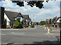
4
Wilford Post Office
On the corner of Main Road and Wilford Lane.
Image: © Alan Murray-Rust
Taken: 29 May 2009
0.04 miles
5
Wilford: a grey July morning in Main Street
Most of the houses at the southern end of the village are twentieth century, but Hunters Farm, in the centre middle distance, had its origins in the seventeenth and was much rebuilt in 1724 - see Image] for a close-up.
Image: © John Sutton
Taken: 19 Jul 2012
0.04 miles
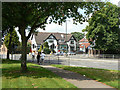
6
Main Road, Wilford
This is the southern end of Main Road from its junction with Wilford Lane. See also Image - there have been a number of changes over seven years including a new garage on the left and 20mph speed limit signs.
Image: © Stephen McKay
Taken: 9 Oct 2019
0.04 miles
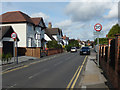
7
Main Road, Wilford
Until the opening of Clifton Bridge in the 1960s, this was the main road out of Nottingham to Ruddington and Gotham, using Wilford Toll Bridge. The bridge is now restricted to pedestrian and cycle use only, so Main Road has become a relatively quiet backwater.
Image: © Alan Murray-Rust
Taken: 29 May 2009
0.05 miles
9
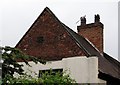
Hunters Farm: dated gable
The gable end is dated 1724 in a slightly darker brick. The farmhouse had its origins in the previous century and is Grade II listed - see http://www.britishlistedbuildings.co.uk/en-457483-hunters-farm-31-and-33-nottingham for the full story.
Image: © John Sutton
Taken: 19 Jul 2012
0.05 miles
10
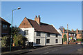
Hunters Farm, Wilford
17th/18th century former farmhouse, with the date 1724 in the gable - difficult to read, better in the larger size image. The rendered finish hides the fact that this is a timber framed building. Listed grade II.
Image: © Alan Murray-Rust
Taken: 9 Jan 2013
0.05 miles