IMAGES TAKEN NEAR TO
Garsdale Drive, NOTTINGHAM, NG11 7DZ
Introduction
This page details the photographs taken nearby to Garsdale Drive, NG11 7DZ by members of the Geograph project.
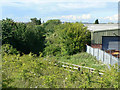
The Geograph project started in 2005 with the aim of publishing, organising and preserving representative images for every square kilometre of Great Britain, Ireland and the Isle of Man.

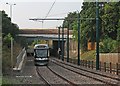
There are currently over 7.5m images from over14,400 individuals and you can help contribute to the project by visiting https://www.geograph.org.uk
Image Map
Images are licensed for reuse under creativecommons.org/licenses/by-sa/2.0
Notes
- Clicking on the map will re-center to the selected point.
- The higher the marker number, the further away the image location is from the centre of the postcode.
Image Listing (99 Images Found)
Images are licensed for reuse under creativecommons.org/licenses/by-sa/2.0
Image
Details
Distance
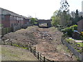
1
Former railway line
This is to be the alignment of the extension of the Nottingham tram route to Clifton. The original railway bridge has been replaced by infill, but the tram will cross the road by a level crossing here. The roadway will be lowered and the tramway raised above the old track bed. This will be the site of a tram stop.
Image: © Alan Murray-Rust
Taken: 21 May 2009
0.07 miles
2
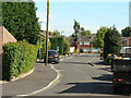
Barnfield
Residential road off Ruddington Lane
Image: © Alan Murray-Rust
Taken: 21 May 2009
0.07 miles
3
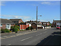
Spinney Way, Silverdale
Typical residential road on this 1960s estate.
Image: © Alan Murray-Rust
Taken: 21 May 2009
0.10 miles
4
Railway cutting exposed
Vegetation has been removed in preparation for construction of the new tramway, opening up the view of the A52 ring road bridge. Ruddington Lane, from which this view is taken, will be lowered, and the cutting partially filled in to create a level crossing and tram stop.
Image: © Alan Murray-Rust
Taken: 1 Apr 2012
0.10 miles
5
South from Ruddington Lane
A Clifton-bound tram drifts down the incline from Ruddington Lane towards the bridge carrying the A52. The stretch of tramway from Coronation Avenue at Wilford to here follows the alignment of the former Great Central Railway main line from Nottingham Victoria to Leicester Central and London Marylebone.
Image] shows the same tram a few moments later.
Image: © John Sutton
Taken: 10 Sep 2015
0.10 miles
6
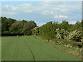
Near Silverdale
At this point the route of the proposed Nottingham tram extension to Clifton will leave the old railway alignment and cross the fields. It will use the old railway bridge under the Ring-road - the line of which can be just followed from the lighting columns - roughly where the lowest part of the skyline is, an head out to the left of the picture.
Image: © Alan Murray-Rust
Taken: 21 May 2009
0.10 miles
7
Looking north from Ruddington Lane
The overhead wiring is complete to a point just beyond the bridge.
Image: © Alan Murray-Rust
Taken: 31 Oct 2014
0.10 miles
8
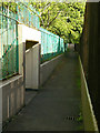
Subway under the Ring Road
Providing a pedestrian link from Silverdale estate to Ruddington Lane. At the time I used it was pleasantly free from both graffiti and smells.
Image: © Alan Murray-Rust
Taken: 21 May 2009
0.10 miles
9
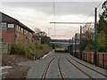
Looking south from Ruddington Lane
Ballast for the track has been laid down, but no tracks as yet. Several of the poles for the overhead have been erected however.
Image: © Alan Murray-Rust
Taken: 23 Jul 2014
0.11 miles
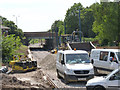
10

Looking south from Ruddington Lane
The machine under the bridge is a tamper carrying out final alignment and bedding of the rails. There will be a new pedestrian way alongside the tramway through to Clifton.
Image: © Alan Murray-Rust
Taken: 8 Sep 2014
0.11 miles