IMAGES TAKEN NEAR TO
Ashdown Close, NOTTINGHAM, NG11 7BD
Introduction
This page details the photographs taken nearby to Ashdown Close, NG11 7BD by members of the Geograph project.
The Geograph project started in 2005 with the aim of publishing, organising and preserving representative images for every square kilometre of Great Britain, Ireland and the Isle of Man.

There are currently over 7.5m images from over14,400 individuals and you can help contribute to the project by visiting https://www.geograph.org.uk
Image Map
Images are licensed for reuse under creativecommons.org/licenses/by-sa/2.0
Notes
- Clicking on the map will re-center to the selected point.
- The higher the marker number, the further away the image location is from the centre of the postcode.
Image Listing (110 Images Found)
Images are licensed for reuse under creativecommons.org/licenses/by-sa/2.0
Image
Details
Distance
1
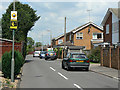
Ashdown Close
Residential cul-de-sac off Wilford Lane.
Image: © Alan Murray-Rust
Taken: 29 May 2009
0.02 miles
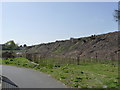
2
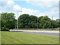
Old railway embankment
The actual embankment is hidden behind the trees. It is however planned to be removed to make way for the proposed tram extension to Clifton. There will be a tram stop at this location on the north side of Wilford Lane.
Image: © Alan Murray-Rust
Taken: 29 May 2009
0.04 miles
3
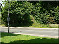
Informal footpath
Leading up onto the old railway embankment. This location will be the site of a level crossing with the proposed tram route to Clifton, and there will be a stop at this point. The end of the embankment will be removed to provide space although the tram will run alongside the embankment further north.
Image: © Alan Murray-Rust
Taken: 29 May 2009
0.05 miles
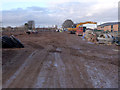
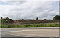
4
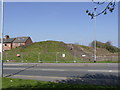
Cleared embankment, Wilford Lane (2)
This will be largely removed to allow the tram to come down to ground level to cross Wilford Lane, and to provide a stop at this point.
Image: © Alan Murray-Rust
Taken: 1 Apr 2012
0.06 miles
5
Wilford: the route of the tramway
Looking north, through the site entrance from the temporary pedestrian path, along the former alignment of the Great Central Railway, which the tramway will follow. The railway embankment has been removed - see Alan Murray-Rust's Image] for how things were in July 2012.
Image: © John Sutton
Taken: 26 Sep 2013
0.06 miles
6
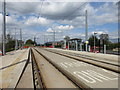
Wilford Lane tram stop
Almost complete. Opening in a few months time.
Image: © Jonathan Thacker
Taken: 1 May 2015
0.06 miles
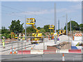
7
Wilford Lane tram stop
The entrance gate was obligingly held open for this shot. Still plenty of work to do here.
Image: © Alan Murray-Rust
Taken: 13 Jan 2014
0.06 miles
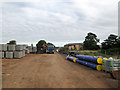
8
Overhead construction machines at Wilford Lane
Erection of the overhead is almost complete on this section.
Image: © Alan Murray-Rust
Taken: 23 Jul 2014
0.06 miles
9
Cleared embankment, Wilford Lane (1)
This will be largely removed to allow the tram to come down to ground level to cross Wilford Lane, and to provide a stop at this point.
Image: © Alan Murray-Rust
Taken: 1 Apr 2012
0.06 miles
10
Cleared embankment, Wilford Lane
Since April http://www.geograph.org.uk/photo/2885525 there has been little structural change, but the stumps of the felled trees have all been rooted out and cleared.
Image: © Alan Murray-Rust
Taken: 27 Jun 2012
0.06 miles