IMAGES TAKEN NEAR TO
Vernon Avenue, NOTTINGHAM, NG11 7AE
Introduction
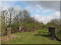
This page details the photographs taken nearby to Vernon Avenue, NG11 7AE by members of the Geograph project.
The Geograph project started in 2005 with the aim of publishing, organising and preserving representative images for every square kilometre of Great Britain, Ireland and the Isle of Man.

There are currently over 7.5m images from over14,400 individuals and you can help contribute to the project by visiting https://www.geograph.org.uk
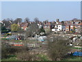
Image Map
Images are licensed for reuse under creativecommons.org/licenses/by-sa/2.0
Notes
- Clicking on the map will re-center to the selected point.
- The higher the marker number, the further away the image location is from the centre of the postcode.
Image Listing (253 Images Found)
Images are licensed for reuse under creativecommons.org/licenses/by-sa/2.0
Image
Details
Distance
1
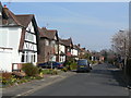
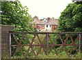
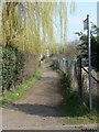
Vernon Avenue
Typical suburban road in Wilford Village.
Image: © Alan Murray-Rust
Taken: 20 Mar 2009
0.02 miles
2
Preparing the footpath
The link through to Wilford is nearly ready for reinstatement.
Image: © Alan Murray-Rust
Taken: 14 Aug 2014
0.04 miles
3
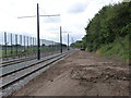
Former Great Central Railway line
The embankment passes to the east of Wilford Village and is earmarked for the proposed tram route to Clifton
Image: © Alan Murray-Rust
Taken: 20 Mar 2009
0.05 miles
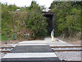
4
Nottingham - NG11 (Wilford Village Area)
A view of the footpath and cycle track that passes beneath a bridge that once carried Great Central Railway (GCR) trains overhead. Presumably this path and cycle track provide easy access between Wilford Village and The Nottingham Emmanuel School (seen in the distance). This 50ft (15m) high embankment forms part of the boundary between Rushcliffe and Nottingham. The railway opened in 1899 and ran from Sheffield to London via Annesley, Nottingham (Victoria), Loughborough Central, Leicester Central, Lutterworth, Rugby and Woodford Halse. Most of the route was closed between 1966-69 as part of the Beeching rationalisation plan.
Image: © David Hallam-Jones
Taken: 2 Jun 2012
0.05 miles
5
Wilford: once a railway
This embankment carried the Great Central Railway main line from Marylebone to Nottingham, Sheffield and Manchester from 1899-1969. The southern extension of the NET tram system to Clifton will run parallel to it, to the right. The bridge is shown in full in Image
Image: © John Sutton
Taken: 7 Apr 2012
0.05 miles
6
Wilford Village
Seen from the former railway embankment. Allotment gardens and typical suburban housing with the church tower behind.
Image: © Alan Murray-Rust
Taken: 20 Mar 2009
0.05 miles
7
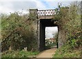
Wilford: Great Central Railway bridge
The blue brick and lattice parapet are typical of overbridges on the Great Central, the last main line to be built (1899) and the first to be closed (1966). This section, from Nottingham to Rugby, remained open until 1969. In due course the southern extension of the NET tramway to Clifton will run parallel to the embankment on this side. Image] is a view from the top of the embankment.
Image: © John Sutton
Taken: 7 Apr 2012
0.06 miles
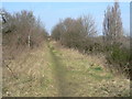
8
Nottingham - NG11 (Wilford Village)
This raised section of the former Great Central Main Line (GCML) railway provides a view of housing and allotments on Holly Ave and of Emmanuel School's playing fields (the latter being behind the photographer). This embankment is also part of the administrative boundary between Rushcliffe and Nottingham. This railway opened in 1899. It started at Annesley and ran southwards for 92 miles (147 km) passing through Nottingham’s Victoria railway station before striking southwards to reach Leicester Central station, passing through Loughborough en route. Most of the route was closed between 1966 and 1969 under the Beeching rationalisation plan. A rudimentary path exists along the former track although not easily accessed.
Image: © David Hallam-Jones
Taken: 2 Jun 2012
0.06 miles
9
Alongside the old railway embankment
Different views become available as the location of the temporary footpath changes.
Image: © Alan Murray-Rust
Taken: 14 Aug 2014
0.06 miles
10
Footpath towards West Bridgford
Like many genuine rights of way within the City of Nottingham, it does not feature on the current 1:50000 map.
Image: © Alan Murray-Rust
Taken: 20 Mar 2009
0.06 miles