IMAGES TAKEN NEAR TO
Starch Lane, NOTTINGHAM, NG10 5EB
Introduction
This page details the photographs taken nearby to Starch Lane, NG10 5EB by members of the Geograph project.
The Geograph project started in 2005 with the aim of publishing, organising and preserving representative images for every square kilometre of Great Britain, Ireland and the Isle of Man.

There are currently over 7.5m images from over14,400 individuals and you can help contribute to the project by visiting https://www.geograph.org.uk
Image Map
Images are licensed for reuse under creativecommons.org/licenses/by-sa/2.0
Notes
- Clicking on the map will re-center to the selected point.
- The higher the marker number, the further away the image location is from the centre of the postcode.
Image Listing (60 Images Found)
Images are licensed for reuse under creativecommons.org/licenses/by-sa/2.0
Image
Details
Distance
1
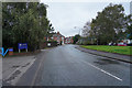
The edge of Sandiacre
The road is Ilkeston Road and to the right of the road behind the trees and houses is the Erewash Canal, a railway line and the River Erewash, so it is no surprise that there were several road signs saying "flood". Thankfully the water had mostly receded.
Image: © Malcolm Neal
Taken: 15 Oct 2019
0.04 miles
2
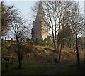
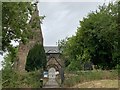
St Giles' Church, Sandiacre, Derbys.
A metallic sign at the side of the footpath that leads up to St Giles' Church, flags up the fact that access to Church Farm is to the photographer's right. Obviously only the lack of foliage makes this view of the church with its unusual tower and spire possible. Apparently splayed-foot broach spires are more common in the South East of England.
Image: © David Hallam-Jones
Taken: 16 Feb 2013
0.07 miles
3
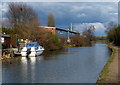
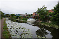
Boat moored along the Erewash Canal in Sandiacre
Image: © Mat Fascione
Taken: 28 Feb 2016
0.07 miles
4
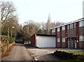
Church Drive, Sandiacre, Derbys.
Some maps continue to identify this building at the junction of Church Drive and Starch Lane - to the photographer's right - as a mill. Although the site may have housed a starch production plant, it now houses the premises of a light industrial enterprise. St Giles' Parish Hall is situated behind the hedge on the left.
Image: © David Hallam-Jones
Taken: 16 Feb 2013
0.07 miles
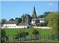
5
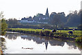
Church Farm, Sandiacre from Erewash Canal
The church of St Giles is also shown. The broach spire which can be seen is 13th century.
Image: © David Pinney
Taken: 21 Oct 2007
0.07 miles
6

Canalside cottages
These semi-detached cottages backing onto the canal are on Lenton Lane, Sandiacre. Most has been made of the waterside back gardens.
Image: © Paul Jewell
Taken: 10 May 2011
0.08 miles
7
St Giles' Church, Sandiacre
Grade I listed. Listing number 1204475.
Image: © Andrew Abbott
Taken: 9 Jun 2020
0.08 miles
9
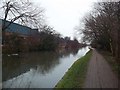
The Erewash Canal at Sandiacre
Canal and towpath pictured here close to the historic centre of the town.
Image: © Jonathan Clitheroe
Taken: 4 Jan 2014
0.08 miles
10
Church Farm
Looking south-west to some very neat old farm buildings in front of St Giles' Church.
Image: © Trevor Rickard
Taken: 18 Sep 2010
0.08 miles