IMAGES TAKEN NEAR TO
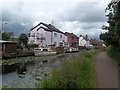
Mark Street, NOTTINGHAM, NG10 5AD
Introduction
This page details the photographs taken nearby to Mark Street, NG10 5AD by members of the Geograph project.
The Geograph project started in 2005 with the aim of publishing, organising and preserving representative images for every square kilometre of Great Britain, Ireland and the Isle of Man.

There are currently over 7.5m images from over14,400 individuals and you can help contribute to the project by visiting https://www.geograph.org.uk
Image Map
Images are licensed for reuse under creativecommons.org/licenses/by-sa/2.0
Notes
- Clicking on the map will re-center to the selected point.
- The higher the marker number, the further away the image location is from the centre of the postcode.
Image Listing (111 Images Found)
Images are licensed for reuse under creativecommons.org/licenses/by-sa/2.0
Image
Details
Distance
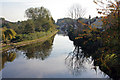
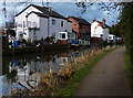
1
The Erewash Canal at Sandiacre
This is the view from Station Road bridge (compare with Image from the lower level).
Image: © Alan Murray-Rust
Taken: 11 Nov 2007
0.06 miles
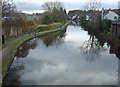
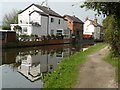
2
Erewash Canal looking south from Sandiacre bridge
The towpath is part of a cycle route known as the Nutbrook Trail.
The canal was built in 1777-1779 for carrying coal from mines near the Erewash Valley to Leicestershire. The canal now takes pleasure crafts.
Image: © David Pinney
Taken: 21 Oct 2007
0.06 miles
3
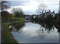
The Erewash Canal at Sandiacre
The view from the towpath at Station Road bridge (compare with Image from up on the bridge). The canal widens here to provide a winding hole to allow boats to be turned round.
Image: © Alan Murray-Rust
Taken: 11 Nov 2007
0.07 miles
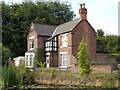
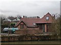
4
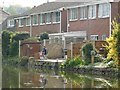
Houses next to the Erewash Canal in Sandiacre
Image: © Mat Fascione
Taken: 28 Feb 2016
0.07 miles
7
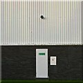
Fire exit
On an industrial unit beside the Erewash Canal in Sandiacre.
Image: © David Lally
Taken: 6 Jun 2014
0.10 miles
8
Watercraft Moored on the Erewash Canal
This peaceful spot is close to the B6002 Road in Sandiacre. The towpath forms part of the Nutbrook Trail.
Image: © Jonathan Clitheroe
Taken: 15 Aug 2013
0.10 miles
9
House in Lock Lane, from the canal towpath
Image: © Christine Johnstone
Taken: 24 Jan 2010
0.10 miles