IMAGES TAKEN NEAR TO
Lakeside Avenue, NOTTINGHAM, NG10 3GJ
Introduction
This page details the photographs taken nearby to Lakeside Avenue, NG10 3GJ by members of the Geograph project.
The Geograph project started in 2005 with the aim of publishing, organising and preserving representative images for every square kilometre of Great Britain, Ireland and the Isle of Man.

There are currently over 7.5m images from over14,400 individuals and you can help contribute to the project by visiting https://www.geograph.org.uk
Image Map
Images are licensed for reuse under creativecommons.org/licenses/by-sa/2.0
Notes
- Clicking on the map will re-center to the selected point.
- The higher the marker number, the further away the image location is from the centre of the postcode.
Image Listing (86 Images Found)
Images are licensed for reuse under creativecommons.org/licenses/by-sa/2.0
Image
Details
Distance
1
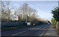
West on Fields Farm Road, Long Eaton
The railway runs on an embankment behind the trees.
Image: © Robin Stott
Taken: 18 Nov 2017
0.12 miles
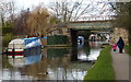
2
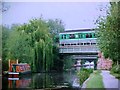
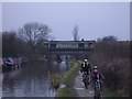
Midland Main Line crosses the Erewash Canal
Image: © Tim Glover
Taken: 27 May 1997
0.14 miles
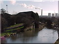
4
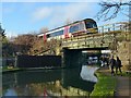
Railway bridge over the Erewash Canal, Sawley (2)
Built in 1840 for the Midland Counties (later Midland) Railway, an early example of a skew bridge, Listed Grade II.
This span over the Erewash Canal is not original, although the stone abutments are. Originally the bridge comprised cast iron arch ribs. These were replaced in the 1905 by the current steel plate girders, The lattice girder was added some years earlier when a footway was added to the south side of the bridge, but is now purely decorative. See the listing description https://historicengland.org.uk/listing/the-list/list-entry/1417992 for very comprehensive information about the bridge, and http://www.geograph.org.uk/photo/5643525 for the east span.
Image: © Alan Murray-Rust
Taken: 1 Jan 2018
0.15 miles
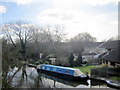
5
Railway bridge crossing the Erewash Canal
Image: © Mat Fascione
Taken: 28 Feb 2016
0.15 miles
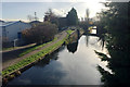
6
Entrance to marina, Erewash Canal
Part of the bridge carrying the Midland Counties Railway can be seen
Image: © Tim Glover
Taken: 17 Jan 1999
0.15 miles
7
South on the Erewash Canal from the Fields Farm Road bridge, Long Eaton
On the left is a corner of the Sheet Stores Industrial Estate. In the distance are the cooling towers of the Ratcliffe on Soar power station Image and neighbouring squares. See also Image
Image: © Robin Stott
Taken: 18 Nov 2017
0.15 miles
8
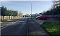
East on Fields Farm Road, Long Eaton
Ahead, the road rises to cross the canal. To the right, Roy Pidcock is a motorbike dealer. Leyland Cypress is getting out of control, left.
Image: © Robin Stott
Taken: 18 Nov 2017
0.15 miles
9
Erewash Canal, Long Eaton
A freight train crosses the Erewash Canal, Long Eaton.
Image: © Andrew Abbott
Taken: 31 Dec 2007
0.15 miles
10
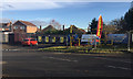
Soldiers & Sailors Hand Car Wash, Fields Farm Road, Long Eaton
Viewed on a sunny morning in mid-November.
Image: © Robin Stott
Taken: 18 Nov 2017
0.15 miles