IMAGES TAKEN NEAR TO
Roosevelt Avenue, NOTTINGHAM, NG10 3GE
Introduction
This page details the photographs taken nearby to Roosevelt Avenue, NG10 3GE by members of the Geograph project.
The Geograph project started in 2005 with the aim of publishing, organising and preserving representative images for every square kilometre of Great Britain, Ireland and the Isle of Man.

There are currently over 7.5m images from over14,400 individuals and you can help contribute to the project by visiting https://www.geograph.org.uk
Image Map
Images are licensed for reuse under creativecommons.org/licenses/by-sa/2.0
Notes
- Clicking on the map will re-center to the selected point.
- The higher the marker number, the further away the image location is from the centre of the postcode.
Image Listing (80 Images Found)
Images are licensed for reuse under creativecommons.org/licenses/by-sa/2.0
Image
Details
Distance
3
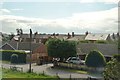
Long Eaton Station
The Eastbound platform is accessed by the path that leads from the ticket office through the gap in the trees visible just to the left.
To access the Westbound platform passengers must walk via Tamworth Road under the adjacent bridge. This can be seen here: Image
Image: © David Lally
Taken: 10 Feb 2008
0.10 miles
4
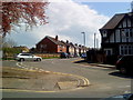
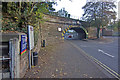
Southwest on Tamworth Road, Long Eaton
Viewed through the railway bridge east of the station on a sunny November morning.
Image: © Robin Stott
Taken: 18 Nov 2017
0.11 miles
5
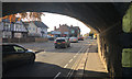
Tamworth Road, Long Eaton
Tamworth Road, once the A453 but now demoted to B road status, is punctuated by this low bridge under the Trent Junction - Derby railway. Long Eaton station, called Sawley Junction until 1968, is immediately to the left of the bridge.
Image: © Stephen McKay
Taken: 17 Oct 2009
0.11 miles
6
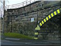
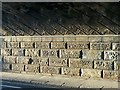
Tamworth Road railway bridge, Sawley ? detail
Wing wall and abutment on the east side of the bridge, see http://www.geograph.org.uk/photo/5643540 for more information.
There is a bench mark http://www.geograph.org.uk/photo/5643535 at the foot of the arch.
Image: © Alan Murray-Rust
Taken: 1 Jan 2018
0.11 miles
7
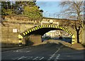
Tamworth Road railway bridge, Sawley
Built in 1839 for the Midland Counties Railway. Listed Grade II it has historical significance as a very early example of a skew arch. See https://historicengland.org.uk/listing/the-list/list-entry/1417676 for the very comprehensive description of the history of the bridge.
A feature of the bridge has always been its very restricted headroom, which has always prevented the use of double deck buses. Local operator Barton Transport experimented with an ultra-low-height bus http://www.old-bus-photos.co.uk/?p=36241 but were never permitted to use it on services under the bridge. As can be seen in the picture, even with the roadway dipping to a lower level under the bridge the allowed height is only 12 ft 3 inches/3.7 metres. Even when first built this was a problem, as the turnpike trustees were concerned about flooding and insisted on a second small arch alongside (at normal ground level) but of course more restricted headroom still. See http://www.geograph.org.uk/photo/55101
Image: © Alan Murray-Rust
Taken: 1 Jan 2018
0.11 miles
8
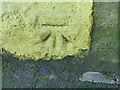
Bench mark, Sawley railway bridge
See http://www.geograph.org.uk/photo/5643542 for location. Rather garishly overpainted in yellow, for reasons that the other picture makes clear.
Image: © Alan Murray-Rust
Taken: 1 Jan 2018
0.11 miles
9
Under the arch, Sawley
The low winter sun lights up the underside of Sawley railway bridge, showing the angled stonework from which the arch is constructed.
This was an early example of a skew bridge from the early years of railway construction, being part of the Midland Counties Railway which was opened in 1839. The bridge was built entirely of stone at the insistence of the Sawley and Nottingham Turnpike who operated the road. Listed Grade II, with a very comprehensive description https://historicengland.org.uk/listing/the-list/list-entry/1417676 . See also http://www.geograph.org.uk/photo/5643540
Image: © Alan Murray-Rust
Taken: 1 Jan 2018
0.11 miles
10
Lift for platform 2
At Long Eaton Station. The lift has been in operation for at least a year now.
Image: © David Lally
Taken: 14 Jun 2014
0.11 miles