IMAGES TAKEN NEAR TO
Fields Farm Road, NOTTINGHAM, NG10 3FZ
Introduction
This page details the photographs taken nearby to Fields Farm Road, NG10 3FZ by members of the Geograph project.
The Geograph project started in 2005 with the aim of publishing, organising and preserving representative images for every square kilometre of Great Britain, Ireland and the Isle of Man.

There are currently over 7.5m images from over14,400 individuals and you can help contribute to the project by visiting https://www.geograph.org.uk
Image Map
Images are licensed for reuse under creativecommons.org/licenses/by-sa/2.0
Notes
- Clicking on the map will re-center to the selected point.
- The higher the marker number, the further away the image location is from the centre of the postcode.
Image Listing (22 Images Found)
Images are licensed for reuse under creativecommons.org/licenses/by-sa/2.0
Image
Details
Distance
1
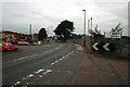
Fields Farm Road
A road through industrial and recent housing estates to the south of Long Eaton. The Nylatex company on the right http://www.geograph.org.uk/photo/930702 has now closed.
Image: © David Lally
Taken: 19 Aug 2010
0.06 miles
2
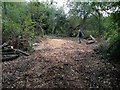
Area of felled trees
In Forbes Hole local nature reserve. Erewash Council acting against the reserve management plan - no surprise there then.
Image: © David Lally
Taken: 13 Sep 2014
0.06 miles

4
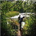
Volunteers litter-picking in Forbes Hole
Image: © David Lally
Taken: 13 Sep 2014
0.10 miles
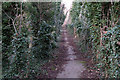
5
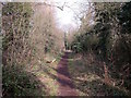
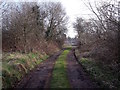
Old railway straight at Forbes Hole
This footpath at Forbes Hole is on the line of an old stretch of the Midland Railway, which fell into disuse when the railways in the area were remodelled to accommodate the Erewash Valley Branch.
Image: © Ian Calderwood
Taken: 11 Mar 2016
0.12 miles
6
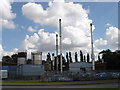
Nylatex Works, Long Eaton
This is located on Farm Fields Road, which is one long strip of factories, industrial parks, and business parks on the edge of Long Eaton.
Image: © Oxymoron
Taken: 21 Aug 2008
0.12 miles
7
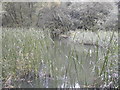
Forbes Hole local nature reserve
The reeds in Forbes hole reserve
Image: © Peter Shone
Taken: 18 Sep 2005
0.13 miles
9
Old railway curve at Forbes Hole
This access track used to be part of the railway, most of which is now under Fields Farm Road.
Image: © Ian Calderwood
Taken: 11 Mar 2016
0.14 miles
10
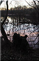
The path round Forbes Hole local nature reserve
This tiny patch of natural chaos is bordered by a railway line industrial estates and roads.
Image: © David Lally
Taken: 9 Feb 2008
0.15 miles