IMAGES TAKEN NEAR TO
Tenter Close, NOTTINGHAM, NG10 1HX
Introduction
This page details the photographs taken nearby to Tenter Close, NG10 1HX by members of the Geograph project.
The Geograph project started in 2005 with the aim of publishing, organising and preserving representative images for every square kilometre of Great Britain, Ireland and the Isle of Man.

There are currently over 7.5m images from over14,400 individuals and you can help contribute to the project by visiting https://www.geograph.org.uk
Image Map
Images are licensed for reuse under creativecommons.org/licenses/by-sa/2.0
Notes
- Clicking on the map will re-center to the selected point.
- The higher the marker number, the further away the image location is from the centre of the postcode.
Image Listing (44 Images Found)
Images are licensed for reuse under creativecommons.org/licenses/by-sa/2.0
Image
Details
Distance
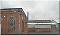
3
Old warehouses at Sheet Stores
These were built for the Midland Railway's factory for the production and warehousing of the tarpaulins used on open railway wagons. This use finished in the 1960s but some of the 19th century buildings survive as a small business park.
Image: © Alan Murray-Rust
Taken: 1 Jan 2018
0.08 miles
5
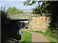
Railway bridge over the Erewash Canal north of Trentlock
Image: © John Slater
Taken: 24 Sep 2013
0.12 miles
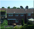
6
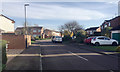
Fosbrooke Drive, Long Eaton
Off Bosworth Way.
Image: © Robin Stott
Taken: 18 Nov 2017
0.13 miles
7
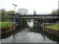
Erewash Canal & towpath heading N towards southern of two railway bridges near Long Eaton Station
Image: © Colin Park
Taken: 11 Feb 2022
0.13 miles
8
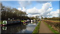
Floodgates on the Erewash Canal
Almost a kilometre from the River Trent, but within its flood plain.
Image: © Christine Johnstone
Taken: 8 May 2019
0.13 miles
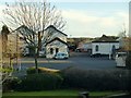
9
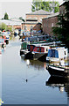
Wyvern Marina
As far as I was aware until reading an information board close to where this was taken from this was still called the Sheet Stores Basin, but apparently not.
The board also enlightened me as to where the curious name of "Sheet Stores" came from: The origin of this group of industrial buildings was as a coal wharf for the Midland Counties Railways in 1840, as the need for canal-transported coal declined this became the Midland Railways Sheet Stores, where tarpaulins were made and repaired. That use finished in 1963 and the area is now a general industrial estate. A boatyard serves the boats, the sound of an angle grinder filled the air at the time that this was taken.
Image: © David Lally
Taken: 25 Apr 2011
0.13 miles
10
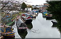
Sheet Stores Basin next to the Erewash Canal
Image: © Mat Fascione
Taken: 28 Feb 2016
0.13 miles