IMAGES TAKEN NEAR TO
East Street, GATESHEAD, NE8 3AR
Introduction
This page details the photographs taken nearby to East Street, NE8 3AR by members of the Geograph project.
The Geograph project started in 2005 with the aim of publishing, organising and preserving representative images for every square kilometre of Great Britain, Ireland and the Isle of Man.

There are currently over 7.5m images from over14,400 individuals and you can help contribute to the project by visiting https://www.geograph.org.uk
Image Map
Images are licensed for reuse under creativecommons.org/licenses/by-sa/2.0
Notes
- Clicking on the map will re-center to the selected point.
- The higher the marker number, the further away the image location is from the centre of the postcode.
Image Listing (315 Images Found)
Images are licensed for reuse under creativecommons.org/licenses/by-sa/2.0
Image
Details
Distance
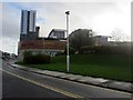
2
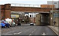
Railway bridge, Hawks Road
The roof of Gateshead College Image can be seen above the bridge on the right. On the left, also beyond the railway line, is the now disused warehouse of Baric Systems photographed here in 2006 Image whose site has now been bought for redevelopment by Gateshead Council.
Hawks Road is named for George Hawks, a Gateshead industrialist and first Mayor Image
Image: © Andrew Curtis
Taken: 16 Feb 2012
0.10 miles
3
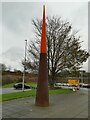
Orange spike, Quaysgate, Gateshead
According to Keith Edkins Image this is one of several illuminated beacons installed in 2004. Maybe more artistic than functional.
Image: © Stephen Craven
Taken: 4 Dec 2021
0.10 miles
4
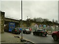
Railway bridge over Hawks Road
See Image for a view from the other side. The Baric Systems building shown to the right of this view in Image has now been demolished, leaving a clear view of the arched viaduct to the right that led into the old Oakwellgate station This was "situated on a 32ft high artificial mound surrounded on three sides by a brick and masonry retaining wall" [Source: https://www.twsitelines.info/SMR/4368 ]. It is still shown as 'Goods Sta' on the 1967 OS map, but beyond the wall is now the car park for the nearby Sage Centre.
Traffic was queuing for at least 300 metres for the junction with the A167 (Tyne Bridge approach).
Image: © Stephen Craven
Taken: 4 Dec 2021
0.10 miles
5
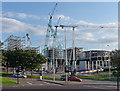
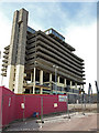
Development, High Street, Gateshead
There's a funny thing about Gateshead. It's pretty big - the council area covers a population of around 200,000 - and yet there's nothing there. No central focus to speak of. The council demolished its most interesting architectural asset (Image]), and here was resorting to the only thing anyone can ever think of nowadays when they talk of urban regeneration, which is to build a large shopping centre. This one looked so large it's almost like starting again.
Image: © Stephen Richards
Taken: 14 Aug 2012
0.11 miles
6
Trinity Square, Gateshead
Looking up High Street towards the corner of Gateshead's large Tesco owned Trinity Square development. The development contains a number of small to medium sized retail units, a cinema, restaurants, a large Tesco Extra supermarket and (in the tall buildings on the roof) flats providing accommodation for 1000 students.
Image: © Graham Robson
Taken: 11 Nov 2013
0.11 miles
7
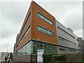
Gateshead College, north-west corner
See Image for a full-length view from across the road.
Image: © Stephen Craven
Taken: 4 Dec 2021
0.13 miles
8
Grey Nags Head and bank building, High St
Viewed from the steps outside the Tesco Extra building, Gateshead.
Image: © Pauline E
Taken: 22 Sep 2013
0.13 miles
9
The Gateshead Trinity Square car park
Demolition in progress.
Image: © wfmillar
Taken: 23 May 2009
0.13 miles
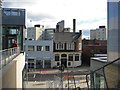
10
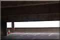
Car park, and cone
View from the 5th floor of the Get Carter carpark
Image: © hayley green
Taken: 27 Apr 2008
0.13 miles